Polska Chatka
Polska Chatka is a convenience store on Cross Street in Athenry, County Galway, on the Square. Carestore, Athenry Opticians and Total Health are within 14 m.
- Street
- Cross Street
- From the Square
- On the Square
- Wheelchair
- Accessible
- Parking
- Athenry Town on North Gate Street, 205 m away
- Bus stop
- The Arch Athenry, 243 m away
The map does not yet record a phone number or a website for Polska Chatka. Anyone can add them on OpenStreetMap; this page picks the change up at the next refresh.
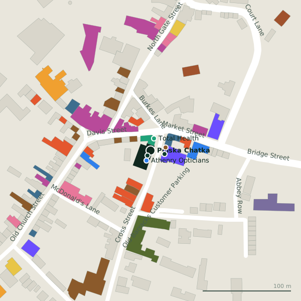
Plan of the surrounding 300 m
Getting to Polska Chatka
- By car
- Park at Athenry Town on North Gate Street, 205 m away, paid, 23 spaces. Athenry is 20 km from Galway city.
- By bus
- The nearest stop is The Arch Athenry, 243 m away.
- Directions from where you are
- Open the model above, tap the pin and choose “Directions here”; the route is drawn from your own position.
While you are there
23 places to eat and drink within 300 m: The Square Inn (17 m), The Central Bar (18 m), Supermac's (38 m) and The Hop Inn (42 m) and more.
14 shops within 300 m, including Elegence Boutique, Vodafone and Athenry Country Market.
Cross Street itself has 15 named places on the map.
Opening hours
As recorded on the map: Mo 10:00-20:00; Tu-Sa 10:00-18:00; PH open
As recorded on OpenStreetMap on 2026-09-18; bank holidays may differ.
Within a short walk
- Carestore6 mMedical supply
- Athenry Opticians12 mOpticians
- Total Health14 mPharmacies
- Bar One Racing16 mBookmaker
- The Square Inn17 mPubs
- Elegence Boutique18 mClothes shops
- The Central Bar18 mPubs
- Tim Holian21 mAccountants
Also on Cross Street
- AIBCash machines
- Athenry OpticiansOpticians
- Bar One RacingBookmaker
- CarestoreMedical supply
- Elegence BoutiqueClothes shops
- KasturiRestaurants
- Lodge At The Old BarracksGuest houses
- O'Hara SolicitorsSolicitors
Everything on Cross Street (15 places)
Other convenience stores in Athenry
Questions people ask
Where is Polska Chatka?
When is Polska Chatka open?
Are there other convenience stores nearby?
Source record: OpenStreetMap node/7561019554, read on 2026-09-18. The street is the mapped address where there is one, otherwise the nearest named road. Distances are straight lines.