Keanes
Keanes is a hardware on Main Street in Clifden, County Galway, on Market Square. King's Paper & Gift Shop, Oifig and fish and Vivian are within 6 m.
- Kind
- Hardware
- Street
- Main Street
- From Market Square
- On Market Square
- Parking
- SuperValu Multistorey on Seaview, 135 m away
- Bus stop
- Clifden (Library), 186 m away
The map does not yet record a phone number, a website or opening hours for Keanes. Anyone can add them on OpenStreetMap; this page picks the change up at the next refresh.
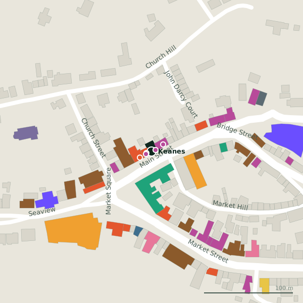
Plan of the surrounding 300 m
Getting to Keanes
- By car
- Park at SuperValu Multistorey on Seaview, 135 m away. Clifden is 69 km from Galway city.
- By bus
- The nearest stop is Clifden (Library), 186 m away, with a shelter.
- Directions from where you are
- Open the model above, tap the pin and choose “Directions here”; the route is drawn from your own position.
While you are there
22 places to eat and drink within 300 m: Oifig and fish (6 m), Marconi Restaurant (15 m), Guy’s Bar (23 m) and E.J. Kings Bar & Restaurant (38 m) and more.
23 shops within 300 m, including King's Paper & Gift Shop, Vivian and Millars.
Main Street itself has 23 named places on the map.
Within a short walk
- King's Paper & Gift Shop5 mGift shops
- Oifig and fish6 mRestaurants
- Vivian6 mClothes shops
- Marconi Restaurant15 mRestaurants
- Millars15 mClothes shops
- Guy’s Bar23 mPubs
- The Central B&B25 mGuest houses
- Foyle’s Hotel26 mHotels
Also on Main Street
- Brown’s RestaurantRestaurants
- Circle KPetrol stations
- Clifden Fruit & Veg MarketGreengrocers
- Clifden PharmacyPharmacies
- Clifden Post OfficePost office
- Connemara BlueGift shops
- Duane's Fish ShopFishmongers
Everything on Main Street (23 places)
Other hardware in Clifden
- P & B Pryce555 mThe Low Road
- Clifden Supply Centre666 mGalway Road
Questions people ask
Where is Keanes?
Are there other hardware nearby?
Source record: OpenStreetMap node/3929634501, read on 2026-09-18. The street is the mapped address where there is one, otherwise the nearest named road. Distances are straight lines.