Galway Road
Galway Road is the N59, a residential street in Clifden, 741 m east of Market Square. It is 2.1 km long, about 26 minutes on foot end to end. It has 15 named places on the map: cash machine, supermarket, guest house and restaurant and more.
- Type
- Residential street (N59)
- Length
- 2.1 km of mapped road
- From Market Square
- 741 m east
- Runs
- from Main Street
- Nearest bus stop
- Clifden (Library), 712 m away
- Parking
- 1 car park on the street: Clifden Coach Park
- Density
- 15 named places over 2.1 km, 0.7 per 100 m
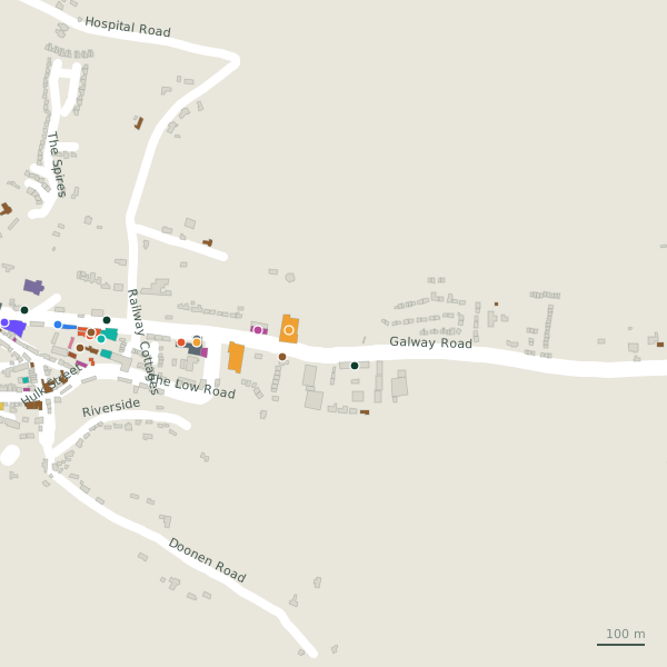
The street is drawn in black; buildings are coloured by what is in them. Drag to turn the model, tap a pin for the place.
Plan of the street
A walk along Galway Road
Walking its length a cash machine, a supermarket, a guest house, a restaurant, a dentist and a fire station and more share the 2.1 km. 1 of the 15 places on the street has opening hours on record. There is parking on the street: Clifden Coach Park.
What is on Galway Road
1 cash machines, 1 supermarkets, 1 guest houses, 1 restaurants and 1 dentists and more, each with its own page.
Restaurants · 2
- Carriage RestaurantRestaurants
- Supermac'sTakeaways
Pubs · 1
- Signal Bar+3539521699Pubs
Shops · 1
- Clifden Supply CentreHardware
Doctors · 1
- Clifden Dental+353 95 22731Dentists · hours on record
Banks · 1
- AIBCash machines
Petrol · 1
- EssoPetrol stations
Gyms and sport · 1
- RenewSports centres
Hotels · 2
- Burkes B & BGuest houses
- The Station House HotelHotels
Other places · 3
- Clifden Fire StationFire station
- Clifden Garda StationGarda station
- Court HouseCourthouse
Streets it joins
- Hospital Roadresidential street
- Main Streetregional road · 23 places
- Railway Cottagesresidential street
- St. Josephs Courtresidential street · 2 places
- The Low Roadlink road · 7 places
Questions people ask
Where is Galway Road?
How long is Galway Road?
What is on Galway Road?
Is there a bus stop on Galway Road?
Where can I park near Galway Road?
Browse by kind
- Cash machines in Clifden
- Supermarkets in Clifden
- Guest houses in Clifden
- Restaurants in Clifden
- Dentists in Clifden
- Fire station in Clifden
- Garda station in Clifden
- Hardware in Clifden
- Courthouse in Clifden
- Petrol stations in Clifden
- Sports centres in Clifden
- Pubs in Clifden
- Convenience stores in Clifden
- Takeaways in Clifden
- Hotels in Clifden
- All 28 streets
Geometry, names and places from OpenStreetMap, read on 2026-09-18. Length is the sum of the mapped segments carrying this name; distances are straight lines from the street's midpoint.