Social services · Dublin Road · Tuam
The Family Centre
The Family Centre is a social service on Dublin Road in Tuam, County Galway, 482 m south-east of the Square. SVP House, Tuam Educate Together National School and St. Patricks Primary School are within 139 m.
- Kind
- Social services
- Street
- Dublin Road
- From the Square
- 482 m south-east
- Parking
- Cathedral Car Park on The Walks, 389 m away
- Bus stop
- Stop (Bus Éireann), 149 m away
The map does not yet record a phone number, a website or opening hours for The Family Centre. Anyone can add them on OpenStreetMap; this page picks the change up at the next refresh.
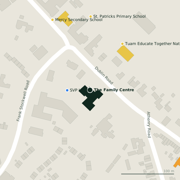
The building in black is this one; drag to turn the model.Open the whole town
Plan of the surrounding 300 m
Getting to The Family Centre
- By car
- Park at Cathedral Car Park on The Walks, 389 m away. Tuam is 30 km from Galway city.
- By bus
- The nearest stop is an unnamed stop, served by Bus Éireann, 149 m away, with a shelter.
- Directions from where you are
- Open the model above, tap the pin and choose “Directions here”; the route is drawn from your own position.
While you are there
1 shop within 300 m, including Centra.
Dublin Road itself has 11 named places on the map, and 2 car parks along it.
Within a short walk
- SVP House43 mSocial services
- 106 m
- St. Patricks Primary School139 mSchools
- Mercy Secondary School150 mSchools
- Archbishop McHale College189 mSchools
- Cill Ghaoithe (Irish Wheelchair Association)191 mSocial services
- Centra213 mConvenience stores
- Tuam Residential Care Centre220 mSocial services
Also on Dublin Road
- Bank of IrelandBanks
- CentraConvenience stores
- Feely's PharmacyPharmacies
- Mercy Secondary SchoolSchools
- NCT CentreVehicle inspection
- St. Patricks Primary SchoolSchools
- SVP HouseSocial services
- TopPetrol stations
Everything on Dublin Road (11 places)
Other social services in Tuam
- SVP House43 mDublin Road
- 191 m
- 220 m
Questions people ask
Where is The Family Centre?
On Dublin Road in Tuam, 482 m south-east of the Square; the nearest car park is 389 m away.
Are there other social services nearby?
3 other social services in $Tuam; the closest is SVP House, 43 m away.
Source record: OpenStreetMap node/6831862232, read on 2026-09-18. The street is the mapped address where there is one, otherwise the nearest named road. Distances are straight lines.