A.W.O.L
A.W.O.L is a tattoo studio on Newtownsmith in Galway, County Galway, 321 m west of Eyre Square. Newtownsmith, Abbeygate Cafe and Bistro and The Abbeygate Townhouse are within 16 m.
- Kind
- Tattoo studios
- Street
- 2 Newtownsmith
- From Eyre Square
- 321 m west
- Phone
- +353 91 441 942
- Website
- awoltattoos.com
- Parking
- Market Street Car Park on Bowling Green, 63 m away
- Bus stop
- Franciscan Friary (Bus Éireann;City Direct), 111 m away
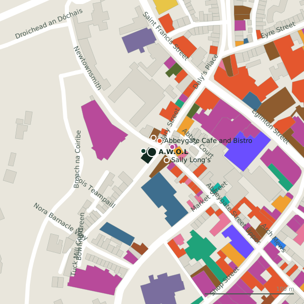
Plan of the surrounding 300 m
Getting to A.W.O.L
- By car
- Park at Market Street Car Park on Bowling Green, 63 m away, paid, 83 spaces.
- By bus
- The nearest stop is Franciscan Friary, served by Bus Éireann;City Direct, 111 m away.
- Directions from where you are
- Open the model above, tap the pin and choose “Directions here”; the route is drawn from your own position.
While you are there
110 places to eat and drink within 300 m: Abbeygate Cafe and Bistro (15 m), Sally Long’s (19 m), Pasta Factory (26 m) and Munch Haven (37 m) and more.
132 shops within 300 m, including Public Romance, Asiatic Manila and WeFix.
Newtownsmith itself has 6 named places on the map, and 2 car parks along it.
Opening hours
As recorded on the map: Mo-Sa 11:00-18:00; Su, PH 13:00-1:00
As recorded on OpenStreetMap on 2026-09-18; bank holidays may differ.
Within a short walk
- Newtownsmith10 mBike hire
- Abbeygate Cafe and Bistro15 mRestaurants
- The Abbeygate Townhouse16 mHotels
- Sally Long’s19 mPubs
- Public Romance24 mClothes shops
- Pasta Factory26 mRestaurants
- Asiatic Manila27 mConvenience stores
- WeFix27 mPhone shops
Also on Newtownsmith
- COPE GalwayCharity shops
- NewtownsmithBike hire
- Papa RichRestaurants
- The Abbeygate TownhouseHotels
Other tattoo studios in Galway
- Galway Tattoos246 mHigh Street
- Junior Tattoo Studio279 mAbbeygate Street Lower
- Obsidian Arts314 mCross Street Lower
- Galway Bay Tattoo376 mDominick Street Lower
- Art Tattoo594 mBohermore
Questions people ask
Where is A.W.O.L?
When is A.W.O.L open?
How do I contact A.W.O.L?
Are there other tattoo studios nearby?
Source record: OpenStreetMap node/9706025382, read on 2026-09-18. The street is the mapped address where there is one, otherwise the nearest named road. Distances are straight lines.