Áras na nGael
Áras na nGael is a community centre on Dominick Street Lower in Galway, County Galway, 671 m south-west of Eyre Square. Galway Arts Centre, Zen dojo and Handsome Burger are within 12 m.
- Street
- 45 Dominick Street Lower
- From Eyre Square
- 671 m south-west
- Phone
- +353 91 567 824
- Website
- arasnangael.ie
- gaillimh@cnag.ie
- Wheelchair
- Accessible
- Parking
- Spanish Arch Car Park on Kirwan's Lane, 180 m away
- Bus stop
- Spanish Arch (Bus Éireann), 185 m away
The map does not yet record opening hours for Áras na nGael. Anyone can add them on OpenStreetMap; this page picks the change up at the next refresh.
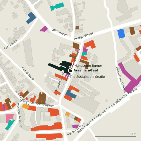
Plan of the surrounding 300 m
Getting to Áras na nGael
- By car
- Park at Spanish Arch Car Park on Kirwan's Lane, 180 m away, paid.
- By bus
- The nearest stop is Spanish Arch, served by Bus Éireann, 185 m away, with a shelter.
- Directions from where you are
- Open the model above, tap the pin and choose “Directions here”; the route is drawn from your own position.
While you are there
97 places to eat and drink within 300 m: Handsome Burger (12 m), dela (20 m), Carroll’s Bar (23 m) and Aniar (27 m) and more.
50 shops within 300 m, including The Sustainable Studio, XL and Corless Formalwear.
Dominick Street Lower itself has 28 named places on the map.
Within a short walk
- Galway Arts Centre6 mMuseums
- Zen dojo8 mChurches
- Handsome Burger12 mTakeaways
- The Sustainable Studio17 mClothes shops
- dela20 mRestaurants
- Carroll’s Bar23 mPubs
- Aniar27 mRestaurants
- Birdhouse29 mTakeaways
Also on Dominick Street Lower
- An Tobar NuaCafés
- AniarRestaurants
- Apache PizzaTakeaways
- BirdhouseTakeaways
- Black 11Escape game
- BóTOWNTakeaways
- Carroll’s BarPubs
- City Pantry CafeCafés
Everything on Dominick Street Lower (28 places)
Other community centres in Galway
- Wave Makers Volunteer Hub301 mSaint Augustine Street
- Saint Joseph's Community Centre1.1 kmCostello Road
- Westside Community Centre1.3 kmSeamus Quirke Road
- TUSLA West Galway Family Services1.3 kmSeamus Quirke Road
- Westside Resource Centre1.3 kmSeamus Quirke Road
- Bohermore Community Centre1.4 kmCookes Terrace
- Liam Mellows GAA Club2.3 kmBallyloughane Road
- 2.8 km
Questions people ask
Where is Áras na nGael?
How do I contact Áras na nGael?
Are there other community centres nearby?
Source record: OpenStreetMap node/1601110544, read on 2026-09-18. The street is the mapped address where there is one, otherwise the nearest named road. Distances are straight lines.