Boots
Boots is a pharmacy on Wellpark Retail Centre in Galway, County Galway, 1.4 km north-east of Eyre Square. Shake Dog, Dunelm and Esquires Coffee are within 33 m.
- Kind
- Pharmacies
- From Eyre Square
- 1.4 km north-east
- Phone
- +35391752702
- Website
- boots.ie
- Run by
- Boots UK Limited
- Bus stop
- Wellpark Retail (Bus Éireann), 85 m away
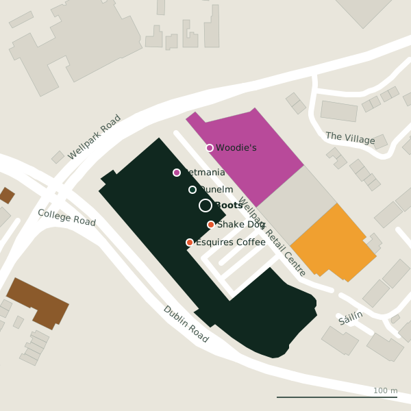
Plan of the surrounding 300 m
Getting to Boots
- By bus
- The nearest stop is Wellpark Retail, served by Bus Éireann, 85 m away.
- Directions from where you are
- Open the model above, tap the pin and choose “Directions here”; the route is drawn from your own position.
While you are there
4 places to eat and drink within 300 m: Shake Dog (16 m), Esquires Coffee (33 m), The Huntsman Inn (151 m) and Friends Restaurant (286 m).
7 shops within 300 m, including Petmania, Woodie's and DFS.
Wellpark Retail Centre itself has 10 named places on the map.
It is open on Sundays (12:00-18:00), which not every place in the town is.
Opening hours
- Mon
- 09:00-18:00
- Tue
- 09:00-18:00
- Wed
- 09:00-18:00
- Thu
- 09:00-19:00
- Fri
- 09:00-19:00
- Sat
- 09:00-18:00
- Sun
- 12:00-18:00
As recorded on OpenStreetMap on 2026-09-18; bank holidays may differ.
Within a short walk
- Shake Dog16 mTakeaways
- Dunelm17 mCurtain
- Esquires Coffee33 mCafés
- Petmania36 mPet shops
- Woodie's48 mHardware
- DFS54 mFurniture
- The G60 mHotels
- Home Store + More77 mHouseware
Also on Wellpark Retail Centre
- DFSFurniture
- DunelmCurtain
- Esquires CoffeeCafés
- Eye CinemaCinema
- Home Store + MoreHouseware
- LidlSupermarkets
- PetmaniaPet shops
- Shake DogTakeaways
Everything on Wellpark Retail Centre (10 places)
Other pharmacies in Galway
- Haven Pharmacy490 mTuam Road
- Renmore Pharmacy764 mRenmore Road
- Duggan's Pharmacy779 mRenmore Road
- McSharry's Pharmacy939 mHeadford Road
- Mervue Pharmacy1.0 kmPlunket Avenue
- Boots1.1 kmHeadford Road
- Matt O'Flaherty Chemists1.1 kmHeadford Road
- Lohan's Pharmacy1.2 kmProspect Hill
Questions people ask
Where is Boots?
When is Boots open?
How do I contact Boots?
Are there other pharmacies nearby?
Source record: OpenStreetMap node/10852900076, read on 2026-09-18. The street is the mapped address where there is one, otherwise the nearest named road. Distances are straight lines.