City Hideaway
City Hideaway is a holiday apartment on Fairgreen Road in Galway, County Galway, 250 m east of Eyre Square. Atlantic Language School, Tobin Consulting Engineers and Fairgreen are within 53 m.
- Street
- Fairgreen Road
- From Eyre Square
- 250 m east
- Website
- cityhideaway.com
- Parking
- Eyre Square Centre Car Park on Whitehall, 376 m away
- Bus stop
- Forster Street (Bus Éireann), 103 m away
The map does not yet record a phone number or opening hours for City Hideaway. Anyone can add them on OpenStreetMap; this page picks the change up at the next refresh.
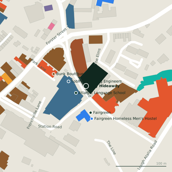
Plan of the surrounding 300 m
Getting to City Hideaway
- By car
- Park at Eyre Square Centre Car Park on Whitehall, 376 m away, paid, 450 spaces.
- By bus
- The nearest stop is Forster Street, served by Bus Éireann, 103 m away.
- Directions from where you are
- Open the model above, tap the pin and choose “Directions here”; the route is drawn from your own position.
While you are there
31 places to eat and drink within 300 m: Top Shelf Coffee Bar (72 m), WYLDE (87 m), HYDE Bar (97 m) and Four Star Pizza (100 m) and more.
9 shops within 300 m, including Centra, Londis and Pick 'N' Pay.
Fairgreen Road itself has 9 named places on the map.
Within a short walk
- Atlantic Language School24 mLanguage school
- Tobin Consulting Engineers36 mEngineers
- Fairgreen53 mBike hire
- Fairgreen Homeless Men's Hostel66 mSocial services
- Bunk Boutique Hostel68 mHostels
- Lakeside Apartments70 mHoliday apartments
- Top Shelf Coffee Bar72 mCafés
- Revenue Commissioners74 mGovernment offices
Also on Fairgreen Road
- Atlantic Language SchoolLanguage school
- FairgreenBike hire
- Fairgreen Homeless Men's HostelSocial services
- IntreoGovernment offices
- Lakeside ApartmentsHoliday apartments
- Revenue CommissionersGovernment offices
- Tobin Consulting EngineersEngineers
- Top Shelf Coffee BarCafés
Other holiday apartments in Galway
- Lakeside Apartments70 mFairgreen Road
- 4.8 km
Questions people ask
Where is City Hideaway?
Are there other holiday apartments nearby?
Source record: OpenStreetMap node/14032229559, read on 2026-09-18. The street is the mapped address where there is one, otherwise the nearest named road. Distances are straight lines.