City Taxi's
City Taxi's is a taxi rank on Eyre Street in Galway, County Galway, 221 m west of Eyre Square. Lapteck, Chat & Net and Lynch Aunctioneers are within 13 m.
- Kind
- Taxi ranks
- Street
- 9 Eyre Street
- From Eyre Square
- 221 m west
- Phone
- +353 91 525252
- Wheelchair
- Accessible
- Parking
- Corrib Centre Car Park, 134 m away
- Bus stop
- Franciscan Friary (Bus Éireann;City Direct), 75 m away
The map does not yet record a website or opening hours for City Taxi's. Anyone can add them on OpenStreetMap; this page picks the change up at the next refresh.
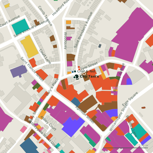
Plan of the surrounding 300 m
Getting to City Taxi's
- By car
- Park at Corrib Centre Car Park, 134 m away, paid.
- By bus
- The nearest stop is Franciscan Friary, served by Bus Éireann;City Direct, 75 m away.
- Directions from where you are
- Open the model above, tap the pin and choose “Directions here”; the route is drawn from your own position.
While you are there
92 places to eat and drink within 300 m: Sip & Bowl (17 m), Hole In The Wall (18 m), McSwiggan’s (24 m) and McSwiggans (32 m) and more.
112 shops within 300 m, including Corner Express, Joe Greenes and Day-Today.
Eyre Street itself has 28 named places on the map, and 1 car park along it.
Within a short walk
- Lapteck5 mComputer
- Chat & Net12 mInternet cafe
- Lynch Aunctioneers13 mEstate agents
- Sip & Bowl17 mCafés
- Hole In The Wall18 mPubs
- Corner Express20 mConvenience stores
- McSwiggan’s24 mRestaurants
- Ladbrokes26 mBookmaker
Also on Eyre Street
- Bank of IrelandCash machines
- CandylandConfectionery
- Carnival SupermarketSupermarkets
- Chat & NetInternet cafe
- Corrib Shopping CentreShopping centres
- DealzVariety stores
- Eyre Square TownhouseGuest houses
- Eyre Street StoresClothes shops
Everything on Eyre Street (28 places)
Other taxi ranks in Galway
- Pro Cabs210 mProspect Hill
- Big O Taxis292 mEyre Square
Questions people ask
Where is City Taxi's?
How do I contact City Taxi's?
Are there other taxi ranks nearby?
Source record: OpenStreetMap node/2102133017, read on 2026-09-18. The street is the mapped address where there is one, otherwise the nearest named road. Distances are straight lines.