Cope Galway
Cope Galway is a social service on Ballybane Industrial Estate in Galway, County Galway, 3.1 km north-east of Eyre Square. KD Autoparts, Marvoy Ltd and Jacobsen Chairs are within 51 m.
- Kind
- Social services
- From Eyre Square
- 3.1 km north-east
- Website
- copegalway.ie
- Run by
- COPE Galway CLG
- Bus stop
- Ballybrit Industrial Estate (Bus Éireann), 429 m away
The map does not yet record a phone number or opening hours for Cope Galway. Anyone can add them on OpenStreetMap; this page picks the change up at the next refresh.
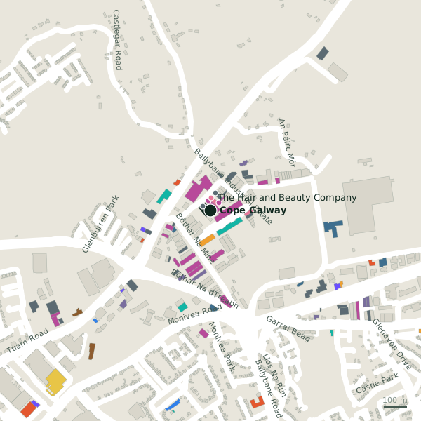
Plan of the surrounding 300 m
Getting to Cope Galway
- By bus
- The nearest stop is Ballybrit Industrial Estate, served by Bus Éireann, 429 m away.
- Directions from where you are
- Open the model above, tap the pin and choose “Directions here”; the route is drawn from your own position.
While you are there
2 places to eat and drink within 300 m: The Galway Plate (180 m) and Royal Rock Cafe (243 m).
20 shops within 300 m, including Marvoy Ltd, Jacobsen Chairs and Advertees Shirts.
Ballybane Industrial Estate itself has 22 named places on the map.
Within a short walk
- KD Autoparts38 mCar parts
- Marvoy Ltd43 mFurniture
- Jacobsen Chairs51 mFurniture
- The Hair and Beauty Company55 mHairdressers
- Advance Pitstop77 mGarages
- Advertees Shirts82 mClothes shops
- SportsKit88 mSports shops
- Connacht Taekwondo Club92 mSports centres
Also on Ballybane Industrial Estate
- Ability WestCharity shops
- ACAL TechnologiesElectronics
- Advance PitstopGarages
- AWP Engineering LtdMetal construction
- Breathnach EngineeringMetal construction
- Eco Wall ThermTrade
- EcoWise InsulationInsulation
Everything on Ballybane Industrial Estate (22 places)
Other social services in Galway
- Ballybrit Social Inclusion Coop759 mOldenway Business Park
- Pope John Paul II Centre1.5 kmBallybane Village
- Coral Haven1.5 kmHeadford Road
- 1.5 km
- 1.5 km
- 1.5 km
- 1.5 km
- 1.5 km
Questions people ask
Where is Cope Galway?
Are there other social services nearby?
Source record: OpenStreetMap node/1944563108, read on 2026-09-18. The street is the mapped address where there is one, otherwise the nearest named road. Distances are straight lines.