Halla an Íarla Rua
Halla an Íarla Rua is a visitor information on Druid Lane in Galway, County Galway, 487 m south-west of Eyre Square. Hall of the Red Earl, The Hall of the Red Earl and Druid are within 9 m.
- Street
- Druid Lane
- From Eyre Square
- 487 m south-west
- Parking
- Spanish Arch Car Park on Kirwan's Lane, 65 m away
- Bus stop
- Jury's Hotel (Bus Éireann), 56 m away
The map does not yet record a phone number, a website or opening hours for Halla an Íarla Rua. Anyone can add them on OpenStreetMap; this page picks the change up at the next refresh.
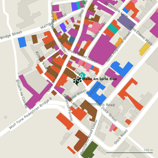
Plan of the surrounding 300 m
Getting to Halla an Íarla Rua
- By car
- Park at Spanish Arch Car Park on Kirwan's Lane, 65 m away, paid.
- By bus
- The nearest stop is Jury's Hotel, served by Bus Éireann, 56 m away.
- Directions from where you are
- Open the model above, tap the pin and choose “Directions here”; the route is drawn from your own position.
While you are there
102 places to eat and drink within 300 m: Kombu Ramen and Bao Bar (20 m), The Lane Cafe (25 m), The Quays (33 m) and Freddy’s (36 m) and more.
83 shops within 300 m, including Enable Ireland, Designs of Ireland and Heart In Hands.
Druid Lane itself has 8 named places on the map, and 1 car park along it.
Other sites within 3 km: Hall of the Red Earl (5 m), Claddagh Ring Museum (45 m), Pat Bracken 1951-2010 (52 m), Richard Martin M.P. 1754-1834 (55 m) and Blake's Castle (71 m).
Within a short walk
- Hall of the Red Earl5 mMonuments
- The Hall of the Red Earl5 mVisitor information
- Druid9 mTheatre
- The Excavation10 mVisitor information
- The 1651 Map12 mVisitor information
- Kombu Ramen and Bao Bar20 mRestaurants
- Flood Street Physiotherapy24 mPhysiotherapist
- The Lane Cafe25 mCafés
Also on Druid Lane
- DruidTheatre
- Hall of the Red EarlMonuments
- Kombu Ramen and Bao BarRestaurants
- The 1651 MapVisitor information
- The ExcavationVisitor information
- The Hall of the Red EarlVisitor information
- The Lane CafeCafés
Other visitor information around Galway
- The Hall of the Red Earl5 mDruid Lane
- The Excavation10 mDruid Lane
- The 1651 Map12 mDruid Lane
- Galway Tourist Information Centre140 mSpanish Parade
- Aran Island Ferries408 mVictoria Place
- Browne Doorway494 mEyre Square
- Aran Island Ferries682 mForster Street
- North Campus2.2 kmCorrib Village
Questions people ask
Where is Halla an Íarla Rua?
Are there other visitor information nearby?
Source record: OpenStreetMap node/12601741262, read on 2026-09-18. The street is the mapped address where there is one, otherwise the nearest named road. Distances are straight lines.