Lidl
Lidl is a supermarket on Western Distributor Road in Galway, County Galway, 3.5 km west of Eyre Square. Insomnia, Speed Queen and Petworld are within 72 m.
- Kind
- Supermarkets
- Street
- Western Distributor Road
- From Eyre Square
- 3.5 km west
- Website
- lidl.ie
- Run by
- Lidl Ireland GmbH
- Wheelchair
- Limited access
- Bus stop
- Stop (City Direct), 199 m away
The map does not yet record a phone number for Lidl. Anyone can add them on OpenStreetMap; this page picks the change up at the next refresh.
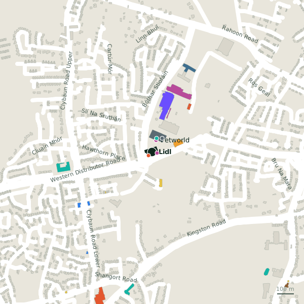
Plan of the surrounding 300 m
Getting to Lidl
- By bus
- The nearest stop is an unnamed stop, served by City Direct, 199 m away.
- Directions from where you are
- Open the model above, tap the pin and choose “Directions here”; the route is drawn from your own position.
While you are there
1 place to eat or drink within 300 m: Insomnia (29 m).
7 shops within 300 m, including Speed Queen, Petworld and Aldi.
Western Distributor Road itself has 29 named places on the map.
Opening hours
As recorded on the map: Mo-Sa 08:00-22:00; Su 09:00-21:00; PH 09:00-21:00
As recorded on OpenStreetMap on 2026-09-18; bank holidays may differ.
Within a short walk
- Insomnia29 mCafés
- Speed Queen29 mLaundries
- Petworld72 mPet shops
- Pure Skill85 mSports centres
- First Stop102 mGarages
- Monkey Business102 mIndoor play
- 105 m
- EcoFuel Ware+Store® Galway123 mPetrol stations
Also on Western Distributor Road
- AldiSupermarkets
- B&QHardware
- B&Q Garden CentreGarden centres
- BootsPharmacies
- Carraig DonnClothes shops
- Dunnes StoresSupermarkets
- EcoFuel Ware+Store® GalwayPetrol stations
Everything on Western Distributor Road (29 places)
Other supermarkets in Galway
- Aldi138 mWestern Distributor Road
- Dunnes Stores368 mWestern Distributor Road
- Tesco898 mShangort Road
- Dunnes Stores1.8 kmSeamus Quirke Road
- Morton's2.0 kmLower Salthill Road
- Aldi2.0 kmOld Seamus Quirke Road
- Tesco2.7 kmFather Griffin Road
- Carnival Supermarket3.3 kmEyre Street
Questions people ask
Where is Lidl?
When is Lidl open?
Are there other supermarkets nearby?
Source record: OpenStreetMap node/11203275102, read on 2026-09-18. The street is the mapped address where there is one, otherwise the nearest named road. Distances are straight lines.