Linderhof B&B
Linderhof B&B is a guest house on Munster Avenue in Galway, County Galway, 980 m south-west of Eyre Square. Train Station Galway, Griffin Lodge B&B and James Heffernan Shoe Repairs are within 76 m.
- Kind
- Guest houses
- Street
- 25 Munster Avenue
- From Eyre Square
- 980 m south-west
- Parking
- Claddagh Church on Claddagh Quay, 333 m away
- Bus stop
- Fr Griffin Road (Bus Éireann), 161 m away
The map does not yet record a phone number, a website or opening hours for Linderhof B&B. Anyone can add them on OpenStreetMap; this page picks the change up at the next refresh.
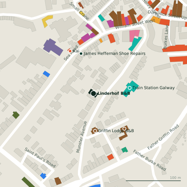
Plan of the surrounding 300 m
Getting to Linderhof B&B
- By car
- Park at Claddagh Church on Claddagh Quay, 333 m away, paid.
- By bus
- The nearest stop is Fr Griffin Road, served by Bus Éireann, 161 m away, with a shelter.
- Directions from where you are
- Open the model above, tap the pin and choose “Directions here”; the route is drawn from your own position.
While you are there
36 places to eat and drink within 300 m: Kai (88 m), Woozza Pizza Takeaway (93 m), Woozza (95 m) and The Crane Bar (109 m) and more.
12 shops within 300 m, including Ernie's, Farraghers Nearbuy and The Laundrette.
Munster Avenue itself has 4 named places on the map.
Within a short walk
- 67 m
- Griffin Lodge B&B68 mGuest houses
- James Heffernan Shoe Repairs76 mShoe repair
- Adare Guest House85 mGuest houses
- Kai88 mRestaurants
- Galway City Medical Centre89 mDoctors
- Woozza Pizza Takeaway93 mRestaurants
- Woozza95 mTakeaways
Also on Munster Avenue
- Blue Teapot TheatreTheatre
- O'Flaherty Funeral ParlourFuneral directors
Other guest houses in Galway
- Griffin Lodge B&B68 mFather Griffin Place
- Adare Guest House85 mFather Griffin Place
- The Stop173 mFather Griffin Road
- Villa Maria B&B317 mFather Griffin Road
- The Swallow B&B338 mFather Griffin Road
- Sli Na Mara B&B389 mWhitestrand Park
- St. Martin's Bed and Breakfast400 mNun's Island
- The Nile Lodge425 mNile Lodge
Questions people ask
Where is Linderhof B&B?
Are there other guest houses nearby?
Source record: OpenStreetMap node/10236070734, read on 2026-09-18. The street is the mapped address where there is one, otherwise the nearest named road. Distances are straight lines.