Banks · Walter Macken Road · Galway
Saint Columbas Credit Union Ltd
Saint Columbas Credit Union Ltd is a bank on Walter Macken Road in Galway, County Galway, 2.3 km east of Eyre Square. Mervue Community Centre, Holy Family Church and HSE Medical Centre are within 122 m.
- Kind
- Banks
- Street
- Walter Macken Road
- From Eyre Square
- 2.3 km east
- Parking
- Clareview Park on Clareview Park, 637 m away
- Bus stop
- Stop (Bus Éireann), 54 m away
The map does not yet record a phone number, a website or opening hours for Saint Columbas Credit Union Ltd. Anyone can add them on OpenStreetMap; this page picks the change up at the next refresh.
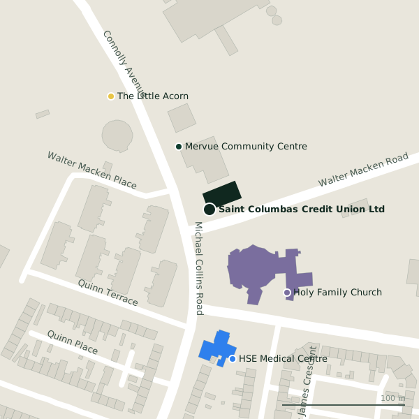
The building in black is this one; drag to turn the model.Open the whole town
Plan of the surrounding 300 m
Getting to Saint Columbas Credit Union Ltd
- By car
- Park at Clareview Park on Clareview Park, 637 m away, free.
- By bus
- The nearest stop is an unnamed stop, served by Bus Éireann, 54 m away.
- Directions from where you are
- Open the model above, tap the pin and choose “Directions here”; the route is drawn from your own position.
While you are there
Nothing else is named on the map within 300 m; the model shows the buildings around it.
Within a short walk
- Mervue Community Centre57 mCommunity centres
- Holy Family Church92 mChurches
- HSE Medical Centre122 mClinics
- The Little Acorn122 mChildcare
Other banks in Galway
- Permanent TSB2.2 kmHeadford Road
- EBS2.3 kmEyre Square
- St. Columba's Credit Union2.4 kmEyre Square
- Permanent TSB2.4 kmEyre Square
- AIB2.6 kmShop Street
- Bank of Ireland2.7 kmMainguard Street
- Saint Anthony and Claddagh Credit Union2.8 kmMainguard Street
- Bank of Ireland3.0 kmDistillery Road
Questions people ask
Where is Saint Columbas Credit Union Ltd?
On Walter Macken Road in Galway, 2.3 km east of Eyre Square; the nearest car park is 637 m away.
Are there other banks nearby?
10 other banks in $Galway; the closest is Permanent TSB, 2.2 km away.
Source record: OpenStreetMap way/160977314, read on 2026-09-18. The street is the mapped address where there is one, otherwise the nearest named road. Distances are straight lines.