SALI Childcare
SALI Childcare is a childcare on Saint Vincent's Avenue in Galway, County Galway, 363 m north-west of Eyre Square. Town Hall Theatre, Galway Courthouse and Scoil an Linbh Íosa are within 43 m.
- Kind
- Childcare
- Street
- Saint Vincent's Avenue
- From Eyre Square
- 363 m north-west
- Website
- www.salichildcare.com
- Parking
- Corrib Centre Car Park, 221 m away
- Bus stop
- Francis Street (Bus Éireann;City Direct), 63 m away
The map does not yet record a phone number or opening hours for SALI Childcare. Anyone can add them on OpenStreetMap; this page picks the change up at the next refresh.
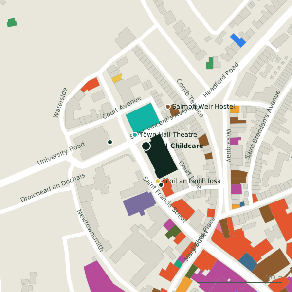
Plan of the surrounding 300 m
Getting to SALI Childcare
- By car
- Park at Corrib Centre Car Park, 221 m away, paid.
- By bus
- The nearest stop is Francis Street, served by Bus Éireann;City Direct, 63 m away.
- Directions from where you are
- Open the model above, tap the pin and choose “Directions here”; the route is drawn from your own position.
While you are there
59 places to eat and drink within 300 m: Brazco (61 m), McGinn’s Hop House (71 m), Hughes’ Bar (76 m) and Corrib House Tearooms (94 m) and more.
54 shops within 300 m, including AgeAction, Chime and thistles.
Saint Vincent's Avenue itself has 2 named places on the map.
Within a short walk
- Town Hall Theatre19 mTheatre
- Galway Courthouse42 mCourthouse
- Scoil an Linbh Íosa43 mSchools
- 48 m
- Salmon Weir Hostel52 mHostels
- TaxAssist Accountants52 mAccountants
- Brazco61 mCafés
- 70 m
Also on Saint Vincent's Avenue
- Salmon Weir HostelHostels
Other childcare in Galway
- Oakwood Creche694 mLower Newcastle Road
- Wonderkids Creche1.1 kmShantalla Road
- Sonas Early Learning Centre Tirellan1.6 kmTirellan Heights
- Amberlee Montessori2.0 kmCuan Glas
- The Little Acorn2.5 kmWalter Macken Place
- Sonas3.0 kmWestern Distributor Road
- The Teddy House3.2 kmÁltan
- Formative Years Montessori3.6 kmGleann Na Rí
Questions people ask
Where is SALI Childcare?
Are there other childcare nearby?
Source record: OpenStreetMap node/3390311957, read on 2026-09-18. The street is the mapped address where there is one, otherwise the nearest named road. Distances are straight lines.