Supermac's
Supermac's is a takeaway on Eyre Square in Galway, County Galway, 122 m west of Eyre Square. The kitchen is listed as burger. 1810 Restaurant and Bar, Card Factory and The Imperial Hotel are within 16 m.
- Kind
- Takeaways
- Street
- Eyre Square
- From Eyre Square
- 122 m west
- Wheelchair
- Accessible
- Parking
- Corrib Centre Car Park, 137 m away
- Bus stop
- Stop, 27 m away
The map does not yet record a phone number, a website or opening hours for Supermac's. Anyone can add them on OpenStreetMap; this page picks the change up at the next refresh.
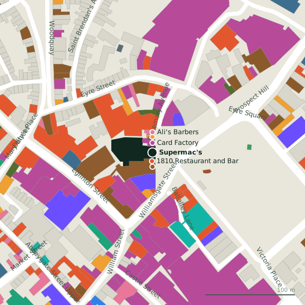
Plan of the surrounding 300 m
Getting to Supermac's
- By car
- Park at Corrib Centre Car Park, 137 m away, paid.
- By bus
- The nearest stop is an unnamed stop, 27 m away, with a shelter.
- Directions from where you are
- Open the model above, tap the pin and choose “Directions here”; the route is drawn from your own position.
While you are there
108 places to eat and drink within 300 m: 1810 Restaurant and Bar (10 m), Cafe Ole (27 m), CoCo ToGo (43 m) and Lil' Bros Pizza (51 m) and more.
120 shops within 300 m, including Card Factory, Daybreak and Golden Discs.
Eyre Square itself has 41 named places on the map.
Within a short walk
- 1810 Restaurant and Bar10 mRestaurants
- Card Factory11 mGift shops
- The Imperial Hotel16 mHotels
- Daybreak18 mConvenience stores
- Ali's Barbers22 mHairdressers
- Cafe Ole27 mCafés
- Permanent TSB33 mBanks
- Brown Doorway34 mBike hire
Also on Eyre Square
- 13 On The GreenPubs
- Big O TaxisTaxi ranks
- Brown DoorwayBike hire
- Browne DoorwayVisitor information
- BudgetCar hire
- Cafe OleCafés
- Caffè NeroCafés
- DaybreakConvenience stores
Everything on Eyre Square (41 places)
Other takeaways in Galway
- Lil' Bros Pizza51 mEyre Square
- Krispy Kreme112 mWilliam Street
- Capital Turkish Kebabs114 mEglinton Street
- 179 m
- Domino's186 mProspect Hill
- Dough Bros186 mEyre Square
- Dungeons & Donuts187 mAbbeygate Street Upper
- Munch Haven193 mAbbeygate Street Upper
Questions people ask
Where is Supermac's?
Are there other takeaways nearby?
Source record: OpenStreetMap node/1743423046, read on 2026-09-18. The street is the mapped address where there is one, otherwise the nearest named road. Distances are straight lines.