Things to do in Aughrim
The battle centre, the Bloody Hollow, Holy Trinity, Kilcommadan, the two abbeys.
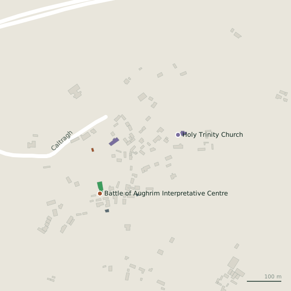
The sights as pins on the model; tap one for its page and directions.
6 things to see
- 01
The Battle of Aughrim centre
191 m south-west of the villageThe museum of the battle of 1691 in the village.
- 02
The Bloody Hollow
1.4 km south-east of the villageThe ground of the battle, 1.4 km out.
- 03
Holy Trinity Church
98 m east of the villageThe church of 1819, still the parish church.
- 04
Kilcommadan
1.9 km south of the villageThe old church 2 km away.
- 05
Kilconnell Abbey
6.4 km north-west of the villageThe friary 6.4 km north.
- 06
Clontuskert Abbey
7.1 km east of the villageThe priory 7 km east towards Ballinasloe.
Things to do
The battlefield
The centre first, then the hollow and the ridge.
Two churches
Holy Trinity and St Catherine's, with the hall and two national schools beside them.
The old road
The R446, once the N6 from Galway to Dublin.
Castles, abbeys and old churches nearby
- 191 m
- Caher House2.7 kmRuins
- 5.4 km
- Kilconnell Abbey6.4 kmAbbeys
- Killure Castle6.8 kmCastles
- Clontuskert Abbey7.1 kmAbbeys
- Ballynabanaba Castle7.8 kmCastles
- Abbey (ruins)10.1 kmRuins
- New Gate10.3 kmRuins
- Eglish Abbey10.7 kmAbbeys
Parks, beaches, lakes and views
- Aughrim Park157 mParks
- Aughrim Playground160 mPlaygrounds
- Cooke's Lough1.0 kmLakes
- Coololla Lough1.1 kmLakes
- Lyons' Lough1.2 kmLakes
- The bloody Hollow1.4 kmAttractions
- Fairfield Lough1.4 kmLakes
- Oak Wood1.7 kmWoods
- West Wood3.8 kmWoods
- 6.5 km
Places to stay
Nothing of the kind named on the map.
The descriptions summarise Wikipedia, "Aughrim, County Galway" (CC BY-SA 4.0, read 2026-09-19); positions and the lists are OpenStreetMap. Opening times and admission are not on record here; check before a visit.