Hotels · Clybaun Road Upper · Galway
Clybaun Hotel
Clybaun Hotel is a hotel on Clybaun Road Upper in Galway, County Galway, 3.9 km west of Eyre Square. NRG Health & Fitness, Knocknacarra Medical Centre and Clybaun Stores are within 231 m.
- Kind
- Hotels
- Street
- Clybaun Road Upper
- From Eyre Square
- 3.9 km west
- Phone
- +353 91 588 088
- Website
- clybaunhotel.ie
- Wheelchair
- Accessible
- Bus stop
- Stop (City Direct), 32 m away
The map does not yet record opening hours for Clybaun Hotel. Anyone can add them on OpenStreetMap; this page picks the change up at the next refresh.
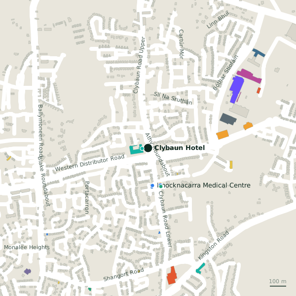
Getting to Clybaun Hotel
- By bus
- The nearest stop is an unnamed stop, served by City Direct, 32 m away.
- Directions from where you are
- Open the model above, tap the pin and choose “Directions here”; the route is drawn from your own position.
While you are there
1 place to eat or drink within 300 m: Tom Sheridan’s (257 m).
1 shop within 300 m, including Clybaun Stores.
Clybaun Road Upper itself has 2 named places on the map.
Within a short walk
- 36 m
- Knocknacarra Medical Centre230 mDoctors
- Clybaun Stores231 mConvenience stores
- Cill Cais Family Practice238 mDoctors
- McSweeneys245 mPharmacies
Also on Clybaun Road Upper
Other hotels in Galway
- Anno Santo Hotel1.4 kmThreadneedle Road
- The Rockbarton Park Hotel1.7 kmRockbarton Park
- Ardilaun Hotel1.7 kmTaylor's Hill Road
- Salthill Hotel1.9 kmSalthill Promenade
- Galway Bay Hotel2.0 kmSalthill Promenade
- Holiday Hotel2.4 kmUpper Salthill Road
- The Continental Boutique Residence2.4 kmLower Salthill Road
- Ward's Hotel2.7 kmLower Salthill Road
Questions people ask
Where is Clybaun Hotel?
On Clybaun Road Upper in Galway, 3.9 km west of Eyre Square.
How do I contact Clybaun Hotel?
By phone on +353 91 588 088, or through clybaunhotel.ie.
Are there other hotels nearby?
44 other hotels in $Galway; the closest is Anno Santo Hotel, 1.4 km away.
Source record: OpenStreetMap way/1087209216, read on 2026-09-18. The street is the mapped address where there is one, otherwise the nearest named road. Distances are straight lines.