Convenience stores · Clybaun Road Lower · Galway
Clybaun Stores
Clybaun Stores is a convenience store on Clybaun Road Lower in Galway, County Galway, 3.9 km west of Eyre Square. It trades under the XL name. Cill Cais Family Practice, McSweeneys and Knocknacarra Medical Centre are within 48 m.
- Street
- Clybaun Road Lower
- From Eyre Square
- 3.9 km west
- Wheelchair
- Accessible
- Bus stop
- Clybaun Road - Windfield Gardens (City Direct), 61 m away
The map does not yet record a phone number, a website or opening hours for Clybaun Stores. Anyone can add them on OpenStreetMap; this page picks the change up at the next refresh.
The building in black is this one; drag to turn the model.Open the whole town
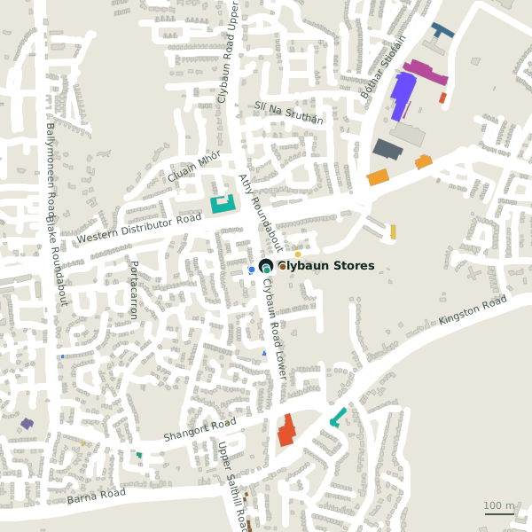
Plan of the surrounding 300 m
Getting to Clybaun Stores
- By bus
- The nearest stop is Clybaun Road - Windfield Gardens, served by City Direct, 61 m away, with a shelter.
- Directions from where you are
- Open the model above, tap the pin and choose “Directions here”; the route is drawn from your own position.
While you are there
1 place to eat or drink within 300 m: Tom Sheridan’s (56 m).
Clybaun Road Lower itself has 6 named places on the map.
Within a short walk
- Cill Cais Family Practice8 mDoctors
- McSweeneys14 mPharmacies
- Knocknacarra Medical Centre48 mDoctors
- Tom Sheridan’s56 mPubs
- Knocknacarra National School114 mSchools
- Clybaun Hotel231 mHotels
- 242 m
Also on Clybaun Road Lower
- Cill Cais Family PracticeDoctors
- Clybaun SurgeryDoctors
- Knocknacarra Medical CentreDoctors
- McSweeneysPharmacies
- Tom Sheridan’sPubs
Other convenience stores in Galway
- Orlik - Polski Sklep556 mKingston Road
- XL1.1 kmUpper Salthill Road
- Cappagh Stores1.4 kmRos Ard
- Daybreak1.4 kmRosán Glas
- Silverstrand Service Station1.8 kmBarna Road
- Hollands of Salthill1.9 kmDalysfort Road
- Spar2.1 kmUpper Salthill Road
- Tesco Express2.2 kmUpper Salthill Road
Questions people ask
Where is Clybaun Stores?
On Clybaun Road Lower in Galway, 3.9 km west of Eyre Square.
Are there other convenience stores nearby?
81 other convenience stores in $Galway; the closest is Orlik - Polski Sklep, 556 m away.
Source record: OpenStreetMap node/1743355866, read on 2026-09-18. The street is the mapped address where there is one, otherwise the nearest named road. Distances are straight lines.