Schools · Doire Gheal · Galway
Knocknacarra National School
Knocknacarra National School is a school on Doire Gheal in Galway, County Galway, 3.8 km west of Eyre Square. Tom Sheridan’s, Clybaun Stores and Cill Cais Family Practice are within 116 m.
- Kind
- Schools
- Street
- Doire Gheal
- From Eyre Square
- 3.8 km west
- Bus stop
- Clybaun Road - Clybaun Court (City Direct), 159 m away
The map does not yet record a phone number, a website or opening hours for Knocknacarra National School. Anyone can add them on OpenStreetMap; this page picks the change up at the next refresh.
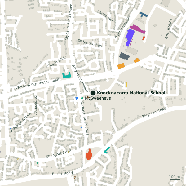
The building in black is this one; drag to turn the model.Open the whole town
Plan of the surrounding 300 m
Getting to Knocknacarra National School
- By bus
- The nearest stop is Clybaun Road - Clybaun Court, served by City Direct, 159 m away.
- Directions from where you are
- Open the model above, tap the pin and choose “Directions here”; the route is drawn from your own position.
While you are there
1 place to eat or drink within 300 m: Tom Sheridan’s (67 m).
1 shop within 300 m, including Clybaun Stores.
Within a short walk
- Tom Sheridan’s67 mPubs
- Clybaun Stores114 mConvenience stores
- Cill Cais Family Practice116 mDoctors
- McSweeneys118 mPharmacies
- Knocknacarra Medical Centre162 mDoctors
Other schools in Galway
- Gaelscoil Mhic Amhlaidh848 mMiller's Lane
- Saint Enda's Secondary School965 mThreadneedle Road
- Salerno Secondary School1.2 kmThreadneedle Road
- 1.4 km
- Knocknacarra Educate Together National School1.4 kmCappagh Road
- Saint Enda's National School1.5 kmDoctor Mannix Road
- Scoil Ide National School1.7 kmÁrd Na Mara
- Taylor's Hill Primary School1.9 kmTaylors Hill Court
Questions people ask
Where is Knocknacarra National School?
On Doire Gheal in Galway, 3.8 km west of Eyre Square.
Are there other schools nearby?
43 other schools in $Galway; the closest is Gaelscoil Mhic Amhlaidh, 848 m away.
Source record: OpenStreetMap way/177278322, read on 2026-09-18. The street is the mapped address where there is one, otherwise the nearest named road. Distances are straight lines.