Costa
Costa is a café in the town in Galway, County Galway, 159 m south of Eyre Square. The kitchen is listed as coffee shop. Edward Square, New Tower and City Walls are within 10 m.
- Kind
- Cafés
- From Eyre Square
- 159 m south
- Wheelchair
- Accessible
- Parking
- Eyre Square Centre Car Park on Whitehall, 37 m away
- Bus stop
- Merchants Road (Bus Éireann), 75 m away
The map does not yet record a phone number or a website for Costa. Anyone can add them on OpenStreetMap; this page picks the change up at the next refresh.
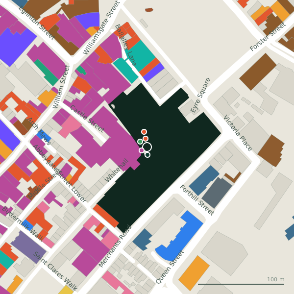
Plan of the surrounding 300 m
Getting to Costa
- By car
- Park at Eyre Square Centre Car Park on Whitehall, 37 m away, paid, 450 spaces.
- By bus
- The nearest stop is Merchants Road, served by Bus Éireann, 75 m away.
- Directions from where you are
- Open the model above, tap the pin and choose “Directions here”; the route is drawn from your own position.
While you are there
111 places to eat and drink within 300 m: Subway (10 m), Insomnia (18 m), Jump Juice (28 m) and Starbucks (69 m) and more.
134 shops within 300 m, including Edward Square, Dunnes Stores and Miramira.
It is open on Sundays (10:30-17:00), which not every place in the town is.
Opening hours
- Mon
- 09:00-18:00
- Tue
- 09:00-18:00
- Wed
- 09:00-18:00
- Thu
- 09:00-19:00
- Fri
- 09:00-19:00
- Sat
- 09:00-18:00
- Sun
- 10:30-17:00
As recorded on OpenStreetMap on 2026-09-18; bank holidays may differ.
Within a short walk
- Edward Square7 mShopping centres
- New Tower9 mTowers
- City Walls10 mAttractions
- Subway10 mTakeaways
- Insomnia18 mCafés
- Dunnes Stores25 mSupermarkets
- Jump Juice28 mTakeaways
- Miramira29 mJewellers
Other cafés in Galway
- Insomnia18 mBallalley Lane
- Starbucks69 mEyre Square
- Pascal Coffee House91 mAbbeygate Street Lower
- Gourmet Tart Co.109 mAbbeygate Street Lower
- Caffè Nero127 mEyre Square
- Butlers Chocolate Café130 mWilliam Street
- Fixx134 mWilliam Street
- Adams Green Provisions139 mWilliamsgate Street
Questions people ask
Where is Costa?
When is Costa open?
Are there other cafés nearby?
Source record: OpenStreetMap node/9010280283, read on 2026-09-18. The street is the mapped address where there is one, otherwise the nearest named road. Distances are straight lines.