Eddie's Take Away and Diner
Eddie's Take Away and Diner is a takeaway on Lios an Uisce in Galway, County Galway, 3.3 km east of Eyre Square. The kitchen is listed as burger. Smako Teka, PFH Training Centre and Educate Together Secondary School are within 31 m.
- Kind
- Takeaways
- Street
- Lios an Uisce
- From Eyre Square
- 3.3 km east
- Wheelchair
- Accessible
- Parking
- Clareview Park on Clareview Park, 948 m away
- Bus stop
- Líos an Uisce (Bus Éireann), 64 m away
The map does not yet record a phone number or a website for Eddie's Take Away and Diner. Anyone can add them on OpenStreetMap; this page picks the change up at the next refresh.
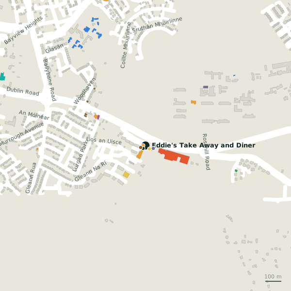
Getting to Eddie's Take Away and Diner
- By car
- Park at Clareview Park on Clareview Park, 948 m away, free.
- By bus
- The nearest stop is Líos an Uisce, served by Bus Éireann, 64 m away, with a shelter.
- Directions from where you are
- Open the model above, tap the pin and choose “Directions here”; the route is drawn from your own position.
While you are there
1 place to eat or drink within 300 m: Poppy Seed (99 m).
2 shops within 300 m, including Smako Teka and McD's.
Lios an Uisce itself has 3 named places on the map.
Opening hours
As recorded on the map: Mo-Th 15:00-24:00, Fr-Su 13:00-23:30
As recorded on OpenStreetMap on 2026-09-18; bank holidays may differ.
Within a short walk
- Smako Teka16 mConvenience stores
- PFH Training Centre24 mCompanies
- 31 m
- Kingsvalley Hotel33 mHotels
- 7th Day Adventist Church50 mChurches
- Poppy Seed99 mRestaurants
- McD's109 mGarden centres
- Formative Years Montessori227 mChildcare
Also on Lios an Uisce
- Kingsvalley HotelHotels
- PFH Training CentreCompanies
Other takeaways in Galway
- Supermac's349 mDublin Road
- Apache Pizza1.5 kmBallybane Road
- Jack Jordans1.6 kmFearann Rí
- China Garden1.7 kmPlunket Avenue
- KFC2.1 kmMonivea Road
- Shake Dog2.3 kmWellpark Retail Centre
- Supermac's2.4 kmTuam Road
- Burger King2.5 kmTuam Road
Questions people ask
Where is Eddie's Take Away and Diner?
When is Eddie's Take Away and Diner open?
Are there other takeaways nearby?
Source record: OpenStreetMap node/1727006536, read on 2026-09-18. The street is the mapped address where there is one, otherwise the nearest named road. Distances are straight lines.