PFH Training Centre
PFH Training Centre is a company on Lios an Uisce in Galway, County Galway, 3.3 km east of Eyre Square. Kingsvalley Hotel, Smako Teka and Eddie's Take Away and Diner are within 24 m.
- Kind
- Companies
- Street
- Lios an Uisce
- From Eyre Square
- 3.3 km east
- Run by
- PFH Technology
- Parking
- Clareview Park on Clareview Park, 956 m away
- Bus stop
- Líos an Uisce (Bus Éireann), 78 m away
The map does not yet record a phone number, a website or opening hours for PFH Training Centre. Anyone can add them on OpenStreetMap; this page picks the change up at the next refresh.
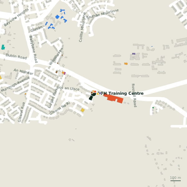
Plan of the surrounding 300 m
Getting to PFH Training Centre
- By car
- Park at Clareview Park on Clareview Park, 956 m away, free.
- By bus
- The nearest stop is Líos an Uisce, served by Bus Éireann, 78 m away, with a shelter.
- Directions from where you are
- Open the model above, tap the pin and choose “Directions here”; the route is drawn from your own position.
While you are there
2 places to eat and drink within 300 m: Eddie's Take Away and Diner (24 m) and Poppy Seed (110 m).
2 shops within 300 m, including Smako Teka and McD's.
Lios an Uisce itself has 3 named places on the map.
Within a short walk
- Kingsvalley Hotel18 mHotels
- Smako Teka21 mConvenience stores
- Eddie's Take Away and Diner24 mTakeaways
- 38 m
- 7th Day Adventist Church62 mChurches
- Poppy Seed110 mRestaurants
- McD's119 mGarden centres
- Formative Years Montessori203 mChildcare
Also on Lios an Uisce
- Eddie's Take Away and DinerTakeaways
- Kingsvalley HotelHotels
Other companies in Galway
- 1.5 km
- Western Plastics1.7 kmBallybrit Industrial Estate Upper
- Lynnwood Business Centre1.7 kmOldenway Business Park
- Monicon1.7 kmBallybrit Industrial Estate Upper
- Brennan & Co SVS1.7 kmBallybrit Industrial Estate Upper
- Industrial Lubraction Services1.7 kmOldenway Business Park
- ISS Facility Services1.7 kmBallybrit Industrial Estate Upper
- Oldenhouse Office Centre1.7 kmOldenway Business Park
Questions people ask
Where is PFH Training Centre?
Are there other companies nearby?
Source record: OpenStreetMap node/7711263822, read on 2026-09-18. The street is the mapped address where there is one, otherwise the nearest named road. Distances are straight lines.