FCE Scan
FCE Scan is a clinic on Briarhill Business Park in Galway, County Galway, 4.5 km north-east of Eyre Square. Kelly Services, Magnus and Irish Wheelchair Association are within 13 m.
- Kind
- Clinics
- Street
- Briarhill Business Park
- From Eyre Square
- 4.5 km north-east
- Bus stop
- Monivea Road (Bus Éireann), 372 m away
The map does not yet record a phone number, a website or opening hours for FCE Scan. Anyone can add them on OpenStreetMap; this page picks the change up at the next refresh.
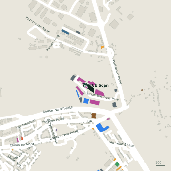
Plan of the surrounding 300 m
Getting to FCE Scan
- By bus
- The nearest stop is Monivea Road, served by Bus Éireann, 372 m away, with a shelter.
- Directions from where you are
- Open the model above, tap the pin and choose “Directions here”; the route is drawn from your own position.
While you are there
2 places to eat and drink within 300 m: Grindhouse Cafe (107 m) and Roots (184 m).
12 shops within 300 m, including The Equine Warehouse, Galway SPCA and Bespoke Sofa & Interiors.
Briarhill Business Park itself has 42 named places on the map.
Within a short walk
- Kelly Services2 mCompanies
- Magnus9 mCompanies
- Irish Wheelchair Association13 mAssociation
- The Equine Warehouse22 mPet shops
- CGA Technology23 mCompanies
- EZ Living furniture Head Office24 mCompanies
- Galway SPCA26 mCharity shops
- Cara Ambulance Service Limited32 mCompanies
Also on Briarhill Business Park
- Acal TechnologiesCompanies
- Anchor Safety LimitedSafety equipment
- AutoglassGarages
- Cara Ambulance Service LimitedCompanies
- CGA TechnologyCompanies
- Connolly's AudiCar dealers
- Connolly's Mercedes-BenzCar dealers
Everything on Briarhill Business Park (42 places)
Other clinics in Galway
- 132 m
- 506 m
- Galway City East Primary Care Centre927 mMerlin Commercial Park
- Lá Nua Psychiatric Day Hospital1.6 kmBallybane Village
- HSE Medical Centre2.3 kmSaint James Crescent
- Carepoint Medical Centre3.6 kmSean Mulvoy Road
- Med Aesthetics3.7 kmSean Mulvoy Road
- Headford Road Medical Clinic3.9 kmHeadford Road
Questions people ask
Where is FCE Scan?
Are there other clinics nearby?
Source record: OpenStreetMap node/11151152213, read on 2026-09-18. The street is the mapped address where there is one, otherwise the nearest named road. Distances are straight lines.