Salt Float & Recovery
Salt Float & Recovery is a clinic in the town in Galway, County Galway, 4.4 km north-east of Eyre Square. Prevos Solutions, Munster Joinery and The Loft are within 7 m.
- Kind
- Clinics
- From Eyre Square
- 4.4 km north-east
- Website
- saltfloatandrecovery.com
- Bus stop
- An Luasán (Bus Éireann), 293 m away
The map does not yet record a phone number for Salt Float & Recovery. Anyone can add them on OpenStreetMap; this page picks the change up at the next refresh.
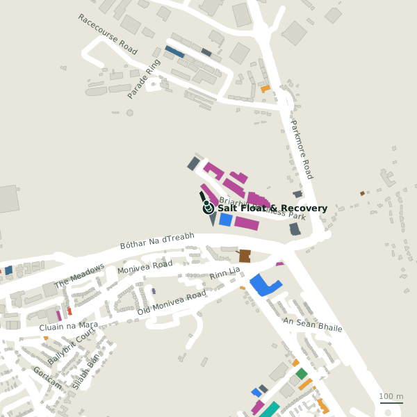
Plan of the surrounding 300 m
Getting to Salt Float & Recovery
- By bus
- The nearest stop is An Luasán, served by Bus Éireann, 293 m away.
- Directions from where you are
- Open the model above, tap the pin and choose “Directions here”; the route is drawn from your own position.
While you are there
3 places to eat and drink within 300 m: Grindhouse Cafe (38 m), Roots (221 m) and Enclosure Bar & Bistro (266 m).
12 shops within 300 m, including NorDan, The Equine Warehouse and Galway SPCA.
It is open on Sundays (10:00-18:00), which not every place in the town is.
Opening hours
- Mon
- 10:00-21:00
- Tue
- 10:00-21:00
- Wed
- 10:00-21:00
- Thu
- 10:00-21:00
- Fri
- 10:00-21:00
- Sat
- 09:00-18:00
- Sun
- 10:00-18:00
As recorded on OpenStreetMap on 2026-09-18; bank holidays may differ.
Within a short walk
- Prevos Solutions4 mIT companies
- Munster Joinery5 mConstruction company
- The Loft7 mCompanies
- Optimum Body25 mPhysiotherapist
- Stephanie Dowling Folan27 mTherapist
- Adare Beverages28 mBeverages
- Bidvest Noonan28 mCompanies
- Claudia Doherty29 mConsulting
Other clinics in Galway
- FCE Scan132 mBriarhill Business Park
- 454 m
- Galway City East Primary Care Centre829 mMerlin Commercial Park
- Lá Nua Psychiatric Day Hospital1.4 kmBallybane Village
- HSE Medical Centre2.2 kmSaint James Crescent
- Carepoint Medical Centre3.5 kmSean Mulvoy Road
- Med Aesthetics3.6 kmSean Mulvoy Road
- Headford Road Medical Clinic3.8 kmHeadford Road
Questions people ask
Where is Salt Float & Recovery?
When is Salt Float & Recovery open?
Are there other clinics nearby?
Source record: OpenStreetMap node/11151237255, read on 2026-09-18. The street is the mapped address where there is one, otherwise the nearest named road. Distances are straight lines.