Sports centres · Galway
GMIT Sports Centre & Gym
GMIT Sports Centre & Gym is a sports centre in the town in Galway, County Galway, 2.5 km east of Eyre Square. Flannery’s Hotel, AIB and Galwegians Restaurant are within 162 m.
- Kind
- Sports centres
- From Eyre Square
- 2.5 km east
- Wheelchair
- Accessible
- Parking
- Clareview Park on Clareview Park, 520 m away
- Bus stop
- Dawn Dairies (Bus Éireann), 120 m away
The map does not yet record a phone number, a website or opening hours for GMIT Sports Centre & Gym. Anyone can add them on OpenStreetMap; this page picks the change up at the next refresh.
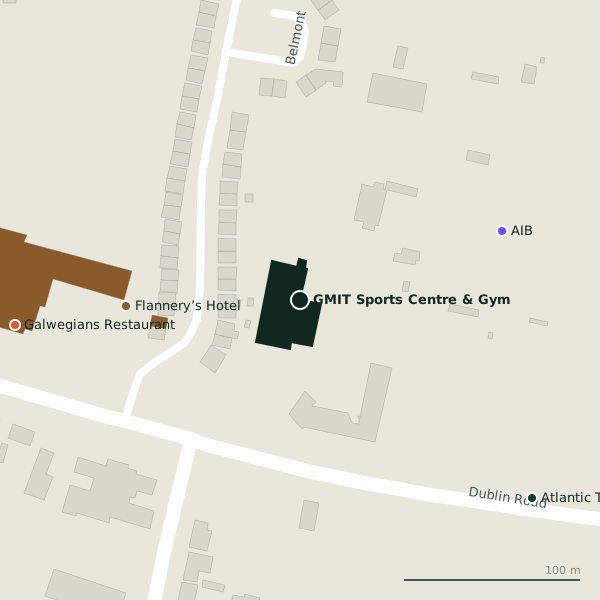
The building in black is this one; drag to turn the model.Open the whole town
Plan of the surrounding 300 m
Getting to GMIT Sports Centre & Gym
- By car
- Park at Clareview Park on Clareview Park, 520 m away, free.
- By bus
- The nearest stop is Dawn Dairies, served by Bus Éireann, 120 m away, with a shelter.
- Directions from where you are
- Open the model above, tap the pin and choose “Directions here”; the route is drawn from your own position.
While you are there
2 places to eat and drink within 300 m: Galwegians Restaurant (162 m) and Frankie's Bar & Bistro (178 m).
Within a short walk
- Flannery’s Hotel99 mHotels
- AIB121 mCash machines
- Galwegians Restaurant162 mRestaurants
- Atlantic Technological University Galway172 mUniversities
- 178 m
- GMIT Library179 mLibrary
Other sports centres in Galway
- Galwegians RFC297 mGlenina Heights
- Kingfisher Gym363 mRenmore Avenue
- 726 m
- Galway United Supporters' Trust FC1.2 kmCastle Park
- Connacht Taekwondo Club1.6 kmGlenrock Business Park
- Ken Horan Kickboxing1.6 kmGlenrock Business Park
- 1.9 km
- Galway Race Course1.9 kmBallybrit
Questions people ask
Where is GMIT Sports Centre & Gym?
In Galway, County Galway, 2.5 km east of Eyre Square; the nearest car park is 520 m away.
Are there other sports centres nearby?
24 other sports centres in $Galway; the closest is Galwegians RFC, 297 m away.
Source record: OpenStreetMap way/210429373, read on 2026-09-18. The street is the mapped address where there is one, otherwise the nearest named road. Distances are straight lines.