It's Magic
It's Magic is a toy on Whitehall in Galway, County Galway, 207 m south of Eyre Square. The CBD Store, Flying Tiger Copenhagen and The Hair Collective are within 18 m.
- Kind
- Toys
- Street
- Whitehall
- From Eyre Square
- 207 m south
- Phone
- +353 563 313
- Website
- itsmagic.ie
- Parking
- Eyre Square Centre Car Park on Whitehall, 26 m away
- Bus stop
- Merchants Road (Bus Éireann), 98 m away
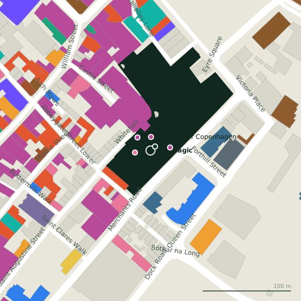
Plan of the surrounding 300 m
Getting to It's Magic
- By car
- Park at Eyre Square Centre Car Park on Whitehall, 26 m away, paid, 450 spaces.
- By bus
- The nearest stop is Merchants Road, served by Bus Éireann, 98 m away.
- Directions from where you are
- Open the model above, tap the pin and choose “Directions here”; the route is drawn from your own position.
While you are there
105 places to eat and drink within 300 m: Costa (49 m), Jump Juice (54 m), Pascal Coffee House (55 m) and Subway (58 m) and more.
136 shops within 300 m, including Flying Tiger Copenhagen, Shannon Dry Cleaners and Born.
Whitehall itself has 6 named places on the map, and 1 car park along it.
It is open on Sundays (12:00-18:00), which not every place in the town is.
Opening hours
- Mon
- 09:30-18:30
- Tue
- 09:30-18:30
- Wed
- 09:30-18:30
- Thu
- 09:30-21:00
- Fri
- 09:30-21:00
- Sat
- 09:30-18:30
- Sun
- 12:00-18:00
As recorded on OpenStreetMap on 2026-09-18; bank holidays may differ.
Within a short walk
- The CBD Store7 mE-cigarette
- Flying Tiger Copenhagen15 mVariety stores
- The Hair Collective18 mHairdressers
- Shannon Dry Cleaners21 mDry cleaners
- Born22 mClothes shops
- Eyre Square Centre28 mShopping centres
- New Tower40 mTowers
- Specsavers40 mOpticians
Also on Whitehall
- Flying Tiger CopenhagenVariety stores
- New TowerTowers
- Shannon Dry CleanersDry cleaners
- The CBD StoreE-cigarette
- The Hair CollectiveHairdressers
Other toys in Galway
- Wooden Heart290 mQuay Street
- Smyths859 mHeadford Road
Questions people ask
Where is It's Magic?
When is It's Magic open?
How do I contact It's Magic?
Are there other toys nearby?
Source record: OpenStreetMap node/9703604405, read on 2026-09-18. The street is the mapped address where there is one, otherwise the nearest named road. Distances are straight lines.