Clothes shops · Forthill Street · Galway
Born
Born is a clothes shop on Forthill Street in Galway, County Galway, 197 m south of Eyre Square. The CBD Store, Specsavers and It's Magic are within 22 m.
- Kind
- Clothes shops
- Street
- Forthill Street
- From Eyre Square
- 197 m south
- Website
- bornclothing.ie
- Parking
- Eyre Square Centre Car Park on Whitehall, 42 m away
- Bus stop
- Merchants Road (Bus Éireann), 78 m away
The map does not yet record a phone number or opening hours for Born. Anyone can add them on OpenStreetMap; this page picks the change up at the next refresh.
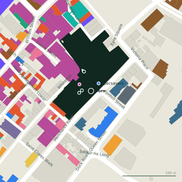
The building in black is this one; drag to turn the model.Open the whole town
Plan of the surrounding 300 m
Getting to Born
- By car
- Park at Eyre Square Centre Car Park on Whitehall, 42 m away, paid, 450 spaces.
- By bus
- The nearest stop is Merchants Road, served by Bus Éireann, 78 m away.
- Directions from where you are
- Open the model above, tap the pin and choose “Directions here”; the route is drawn from your own position.
While you are there
90 places to eat and drink within 300 m: Jump Juice (40 m), Costa (47 m), Subway (57 m) and Insomnia (65 m) and more.
126 shops within 300 m, including Flying Tiger Copenhagen, Shannon Dry Cleaners and Edward Square.
Within a short walk
- The CBD Store17 mE-cigarette
- Specsavers20 mOpticians
- It's Magic22 mToys
- Flying Tiger Copenhagen25 mVariety stores
- New Tower39 mTowers
- Shannon Dry Cleaners39 mDry cleaners
- Jump Juice40 mTakeaways
- Rooney Property Consultants40 mEstate agents
Other clothes shops in Galway
- Penneys49 mMerchants Road
- 58 m
- Fresh Cuts79 mAbbeygate Street Lower
- Swamp85 mBallalley Lane
- Diesel94 mBallalley Lane
- Vero Moda97 mBallalley Lane
- 101 m
- Louis Copeland and Sons104 mMerchants Road
Questions people ask
Where is Born?
On Forthill Street in Galway, 197 m south of Eyre Square; the nearest car park is 42 m away.
Are there other clothes shops nearby?
63 other clothes shops in $Galway; the closest is Penneys, 49 m away.
Source record: OpenStreetMap node/1755903209, read on 2026-09-18. The street is the mapped address where there is one, otherwise the nearest named road. Distances are straight lines.