McDonaghs Hardware
McDonaghs Hardware is a hardware on Bóthar Na Míne in Galway, County Galway, 2.9 km north-east of Eyre Square. Not New Trading, Royal Rock Cafe and Team Sport are within 56 m.
- Kind
- Hardware
- Street
- Bóthar Na Míne
- From Eyre Square
- 2.9 km north-east
- Bus stop
- Ballybrit Industrial Estate (Bus Éireann), 262 m away
The map does not yet record a phone number, a website or opening hours for McDonaghs Hardware. Anyone can add them on OpenStreetMap; this page picks the change up at the next refresh.
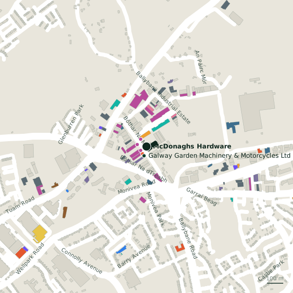
Plan of the surrounding 300 m
Getting to McDonaghs Hardware
- By bus
- The nearest stop is Ballybrit Industrial Estate, served by Bus Éireann, 262 m away.
- Directions from where you are
- Open the model above, tap the pin and choose “Directions here”; the route is drawn from your own position.
While you are there
2 places to eat and drink within 300 m: Royal Rock Cafe (50 m) and Supermac's (288 m).
20 shops within 300 m, including Not New Trading, Team Sport and The Fisherman Factory Shop.
Bóthar Na Míne itself has 23 named places on the map.
Within a short walk
- Not New Trading45 mFurniture
- Royal Rock Cafe50 mCafés
- Team Sport56 mSports shops
- The Fisherman Factory Shop58 mFishmongers
- 59 m
- Central Bearing Supplies Lys69 mMetal construction
- Abbastanza70 mConvenience stores
- Proslide Quality Wardrobes74 mFurniture
Also on Bóthar Na Míne
- Austom Galway LtdTrade
- B&C Paint CentrePaint
- Central Bearing Supplies LysMetal construction
- Clearys Loss Assessors & InsuranceInsurance
- DPD - Depot 31 GalwayPost depot
- Eastern ElectricalElectrical
- Elegant Sliding WardrobesFurniture
- Flaherty MarketsElectrical
Everything on Bóthar Na Míne (23 places)
Other hardware in Galway
- Doorware209 mGlenrock Business Park
- Caufields Hardware223 mTuam Road
- Walsh Plumbing & Heating227 mBóthar Na Míne
- Chadwicks1.3 kmWellpark Road
- Woodie's1.5 kmWellpark Retail Centre
- Tripart1.6 kmTuam Road
- 1.8 km
- Woodie's2.7 kmHeadford Road
Questions people ask
Where is McDonaghs Hardware?
Are there other hardware nearby?
Source record: OpenStreetMap node/1734342834, read on 2026-09-18. The street is the mapped address where there is one, otherwise the nearest named road. Distances are straight lines.