Subway
Subway is a takeaway on Newcastle Road in Galway, County Galway, 959 m west of Eyre Square. The kitchen is listed as sandwich. Apache Pizza, Londis and MixGreens are within 18 m.
- Kind
- Takeaways
- Street
- 31 Newcastle Road
- From Eyre Square
- 959 m west
- Parking
- Car Park 1 on Newcastle Road, 64 m away
- Bus stop
- UCH Galway (Bus Éireann;City Direct), 24 m away
The map does not yet record a phone number, a website or opening hours for Subway. Anyone can add them on OpenStreetMap; this page picks the change up at the next refresh.
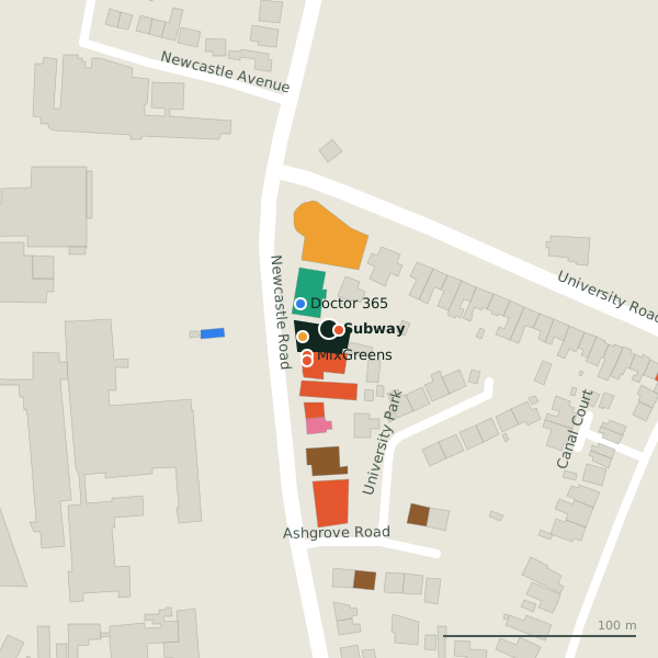
Plan of the surrounding 300 m
Getting to Subway
- By car
- Park at Car Park 1 on Newcastle Road, 64 m away, paid.
- By bus
- The nearest stop is UCH Galway, served by Bus Éireann;City Direct, 24 m away.
- Directions from where you are
- Open the model above, tap the pin and choose “Directions here”; the route is drawn from your own position.
While you are there
11 places to eat and drink within 300 m: Apache Pizza (5 m), MixGreens (18 m), Kawa Asian Street Food (20 m) and Supermac's (33 m) and more.
2 shops within 300 m, including Londis and Tesco Express.
Newcastle Road itself has 23 named places on the map, and 2 car parks along it.
Within a short walk
- Apache Pizza5 mTakeaways
- Londis14 mConvenience stores
- MixGreens18 mCafés
- Doctor 36520 mDoctors
- Kawa Asian Street Food20 mRestaurants
- The Doctors Clinic24 mDoctors
- University Late Night Pharmacy27 mPharmacies
- Supermac's33 mTakeaways
Also on Newcastle Road
- AbrakebabraTakeaways
- Apache PizzaTakeaways
- Coolavalla B&BGuest houses
- Desota House Bed and BreakfastGuest houses
- Doctor 365Doctors
- Gourmet Tart Co.Cafés
- Jalan JalanRestaurants
Everything on Newcastle Road (23 places)
Other takeaways in Galway
- Apache Pizza5 mNewcastle Road
- Supermac's33 mNewcastle Road
- Abrakebabra87 mNewcastle Road
- Zambrero94 mNewcastle Road
- BóTOWN698 mDominick Street Lower
- Munch Haven698 mAbbeygate Street Upper
- Birdhouse710 mDominick Street Lower
- Handsome Burger714 mDominick Street Lower
Questions people ask
Where is Subway?
Are there other takeaways nearby?
Source record: OpenStreetMap node/10299267719, read on 2026-09-18. The street is the mapped address where there is one, otherwise the nearest named road. Distances are straight lines.