Cooke’s Thatch Bar
Cooke’s Thatch Bar is a pub on Newcastle Road in Galway, County Galway, 931 m west of Eyre Square. Moughans, Order of Malta and Desota House Bed and Breakfast are within 84 m.
- Kind
- Pubs
- Street
- 2 Newcastle Road
- From Eyre Square
- 931 m west
- Wheelchair
- Accessible
- Parking
- Free Parking on Gaol Road, 397 m away
- Bus stop
- Stop, 220 m away
The map does not yet record a phone number, a website or opening hours for Cooke’s Thatch Bar. Anyone can add them on OpenStreetMap; this page picks the change up at the next refresh.
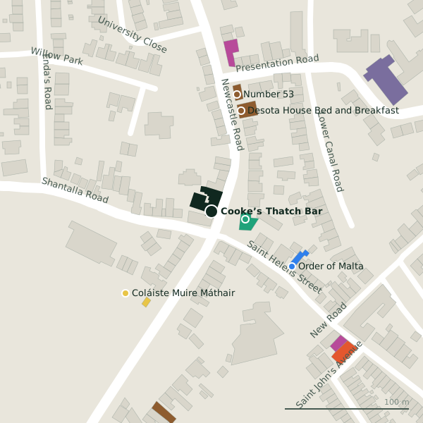
Plan of the surrounding 300 m
Getting to Cooke’s Thatch Bar
- By car
- Park at Free Parking on Gaol Road, 397 m away.
- By bus
- The nearest stop is an unnamed stop, 220 m away.
- Directions from where you are
- Open the model above, tap the pin and choose “Directions here”; the route is drawn from your own position.
While you are there
1 place to eat or drink within 300 m: Hooked (154 m).
2 shops within 300 m, including The Gourmet Offensive and Ali's Fish Market.
Newcastle Road itself has 23 named places on the map, and 2 car parks along it.
Within a short walk
- Moughans28 mPharmacies
- Order of Malta78 mSocial services
- Desota House Bed and Breakfast84 mGuest houses
- Coláiste Muire Máthair95 mSchools
- Number 5396 mGuest houses
- 119 m
- George Conboy Electrical132 mElectrical
- Ali's Fish Market147 mFishmongers
Also on Newcastle Road
- AbrakebabraTakeaways
- Apache PizzaTakeaways
- Coolavalla B&BGuest houses
- Desota House Bed and BreakfastGuest houses
- Doctor 365Doctors
- Gourmet Tart Co.Cafés
- Jalan JalanRestaurants
- Kawa Asian Street FoodRestaurants
Everything on Newcastle Road (23 places)
Other pubs in Galway
- The Crane Bar323 mSea Road
- Massimo328 mWilliam Street West
- The Universal331 mWilliam Street West
- Bierhaus344 mHenry Street
- The Blue Note344 mWilliam Street West
- The Sliding Rock369 mNewcastle Road
- John Keogh’s375 mDominick Street Upper
- Taylor’s384 mDominick Street Upper
Questions people ask
Where is Cooke’s Thatch Bar?
Are there other pubs nearby?
Source record: OpenStreetMap node/12029554541, read on 2026-09-18. The street is the mapped address where there is one, otherwise the nearest named road. Distances are straight lines.