Cash machines · Renmore Road · Galway
Ulster Bank
Ulster Bank is a cash machine on Renmore Road in Galway, County Galway, 1.9 km east of Eyre Square. Duggan's Pharmacy, Renmore Post Office and Spar are within 9 m.
- Kind
- Cash machines
- Street
- Renmore Road
- From Eyre Square
- 1.9 km east
- Run by
- Ulster Bank
- Bus stop
- Bon Secours Hospl (Bus Éireann), 5 m away
The map does not yet record a phone number, a website or opening hours for Ulster Bank. Anyone can add them on OpenStreetMap; this page picks the change up at the next refresh.
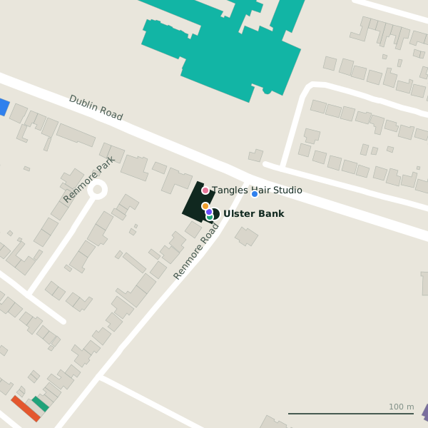
The building in black is this one; drag to turn the model.Open the whole town
Plan of the surrounding 300 m
Getting to Ulster Bank
- By bus
- The nearest stop is Bon Secours Hospl, served by Bus Éireann, 5 m away.
- Directions from where you are
- Open the model above, tap the pin and choose “Directions here”; the route is drawn from your own position.
While you are there
1 place to eat or drink within 300 m: The Full Duck (215 m).
1 shop within 300 m, including Spar.
Renmore Road itself has 8 named places on the map.
Within a short walk
- Duggan's Pharmacy4 mPharmacies
- Renmore Post Office4 mPost office
- Spar9 mConvenience stores
- Tangles Hair Studio20 mHairdressers
- Bon Secours Hospital Galway36 mHospital
- Connacht Hotel Galway92 mHotels
- 114 m
- Renmore Dental195 mDentists
Also on Renmore Road
- Bon Secours Hospital GalwayHospital
- Duggan's PharmacyPharmacies
- Renmore PharmacyPharmacies
- Renmore Post OfficePost office
- Saint Patrick's Garrison ChurchChurches
- SparConvenience stores
- The Full DuckCafés
Other cash machines in Galway
- Bank of Ireland384 mDublin Road
- 724 m
- Bank of Ireland815 mMervue Industrial Estate
- Bank of Ireland947 mMoneenageisha Court
- AIB1.1 kmTuam Road
- Bank of Ireland1.2 kmSean Mulvoy Road
- Euronet1.2 kmDublin Road
- Bank of Ireland1.3 kmTuam Road
Questions people ask
Where is Ulster Bank?
On Renmore Road in Galway, 1.9 km east of Eyre Square.
Are there other cash machines nearby?
24 other cash machines in $Galway; the closest is Bank of Ireland, 384 m away.
Source record: OpenStreetMap node/1869931513, read on 2026-09-18. The street is the mapped address where there is one, otherwise the nearest named road. Distances are straight lines.