Urban Wellbeing
Urban Wellbeing is a hairdresser on Tuam Road in Galway, County Galway, 1.3 km north-east of Eyre Square. The Pole Garage, Tracey's Hot Yoga and Hotworx are within 10 m.
- Kind
- Hairdressers
- Street
- Tuam Road
- From Eyre Square
- 1.3 km north-east
- Phone
- +353 87 264 2922
- Website
- urbanwellbeing.ie
- Bus stop
- Stop (Bus Éireann), 205 m away
The map does not yet record opening hours for Urban Wellbeing. Anyone can add them on OpenStreetMap; this page picks the change up at the next refresh.
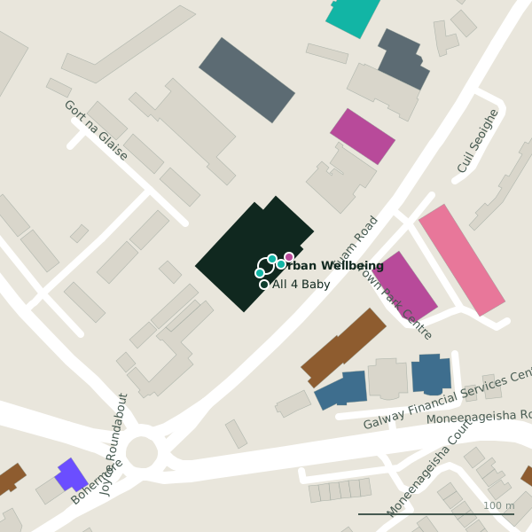
Plan of the surrounding 300 m
Getting to Urban Wellbeing
- By bus
- The nearest stop is an unnamed stop, served by Bus Éireann, 205 m away, with a shelter.
- Directions from where you are
- Open the model above, tap the pin and choose “Directions here”; the route is drawn from your own position.
While you are there
2 places to eat and drink within 300 m: Friends Restaurant (115 m) and Subway (153 m).
15 shops within 300 m, including Ability West, Kingsize Big & Tall Menswear and Fineline Furniture.
Tuam Road itself has 101 named places on the map.
Within a short walk
- The Pole Garage6 mGyms
- 6 m
- Hotworx10 mGyms
- All 4 Baby12 mBaby goods
- Ability West16 mCharity shops
- Kingsize Big & Tall Menswear21 mClothes shops
- Shaolin MMA24 mDojo
- Fineline Furniture28 mFurniture
Also on Tuam Road
- Ability WestCharity shops
- Ace PrintersPrinter ink
- African Pride StoreConvenience stores
- AIBCash machines
- All 4 BabyBaby goods
- ApplegreenPetrol stations
- Atlantic Print & DesignCopyshop
- Bank of IrelandCash machines
Everything on Tuam Road (101 places)
Other hairdressers in Galway
- Fat Tony's281 mTuam Road
- Belle Hair374 mTuam Road
- Talents Hair Creation526 mTerryland Retail Park
- Habib Unisex Barber Shop538 mHeadford Road
- Terryland Barber Shop577 mTerryland Retail Park
- Peter Mark Hairdresser587 mHeadford Road
- Haircare Hairstylist780 mHeadford Road
- Kozzys Barber Shop843 mHeadford Road
Questions people ask
Where is Urban Wellbeing?
How do I contact Urban Wellbeing?
Are there other hairdressers nearby?
Source record: OpenStreetMap node/10582546887, read on 2026-09-18. The street is the mapped address where there is one, otherwise the nearest named road. Distances are straight lines.