Applegreen
Applegreen is a petrol station on Tuam Road in Galway, County Galway, 1.8 km north-east of Eyre Square. Burger King, Wash Me and Hogan Motros are within 56 m.
- Kind
- Petrol stations
- Street
- Tuam Road
- From Eyre Square
- 1.8 km north-east
- Phone
- +353 91 381 156
- Website
- locations.applegreen.com
- Bus stop
- Tuam Road (Bus Éireann), 71 m away
The map does not yet record opening hours for Applegreen. Anyone can add them on OpenStreetMap; this page picks the change up at the next refresh.
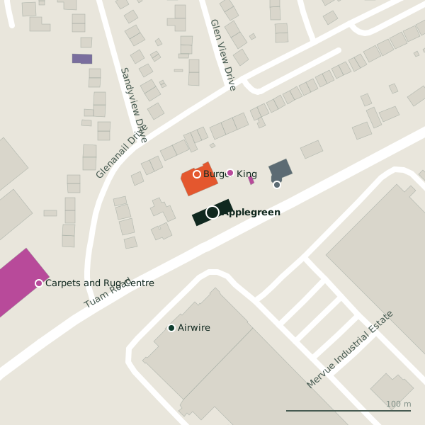
Plan of the surrounding 300 m
Getting to Applegreen
- By bus
- The nearest stop is Tuam Road, served by Bus Éireann, 71 m away, with a shelter.
- Directions from where you are
- Open the model above, tap the pin and choose “Directions here”; the route is drawn from your own position.
While you are there
5 places to eat and drink within 300 m: Burger King (33 m), Friendly Bistro (192 m), Mocha Beans (250 m) and COCO Café (291 m) and more.
10 shops within 300 m, including Wash Me, Carpets and Rug Centre and Classic Tiles & Bathroom World.
Tuam Road itself has 101 named places on the map.
Within a short walk
- Burger King33 mTakeaways
- Wash Me35 mLaundries
- Hogan Motros56 mCar dealers
- Airwire98 mCompanies
- Carpets and Rug Centre150 mFurniture
- Classic Tiles & Bathroom World158 mFurniture
- Galway Mosque East159 mChurches
- Little Teapot Bakery165 mBakeries
Also on Tuam Road
- Ability WestCharity shops
- Ace PrintersPrinter ink
- African Pride StoreConvenience stores
- AIBCash machines
- All 4 BabyBaby goods
- Atlantic Print & DesignCopyshop
- Bank of IrelandCash machines
- Belle HairHairdressers
Everything on Tuam Road (101 places)
Other petrol stations in Galway
- Circle K644 mCollege Road
- Circle K Express966 mTuam Road
- Sweeney Oil980 mHeadford Road
- Circle K1.6 kmBóthar Na dTreabh
- Texaco2.0 kmLough Atalia Road
- Circle K2.3 kmLower Newcastle Road
- Circle K2.9 kmSeamus Quirke Road
- Maxol3.2 kmFather Griffin Road
Questions people ask
Where is Applegreen?
How do I contact Applegreen?
Are there other petrol stations nearby?
Source record: OpenStreetMap node/12889479906, read on 2026-09-18. The street is the mapped address where there is one, otherwise the nearest named road. Distances are straight lines.