Circle K
Circle K is a petrol station on Lower Newcastle Road in Galway, County Galway, 1.3 km north-west of Eyre Square. Bank of Ireland, Revolution Laundry and Kingfisher, NUIG are within 52 m.
- Kind
- Petrol stations
- Street
- Lower Newcastle Road
- From Eyre Square
- 1.3 km north-west
- Run by
- Circle K
- Wheelchair
- Accessible
- Parking
- Car Park 2 on Newcastle Avenue, 463 m away
- Bus stop
- Snipe Avenue 524401 (Bus Éireann;City Direct), 41 m away
The map does not yet record a phone number, a website or opening hours for Circle K. Anyone can add them on OpenStreetMap; this page picks the change up at the next refresh.
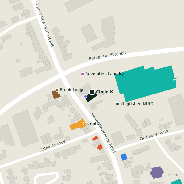
Plan of the surrounding 300 m
Getting to Circle K
- By car
- Park at Car Park 2 on Newcastle Avenue, 463 m away, paid.
- By bus
- The nearest stop is Snipe Avenue 524401, served by Bus Éireann;City Direct, 41 m away.
- Directions from where you are
- Open the model above, tap the pin and choose “Directions here”; the route is drawn from your own position.
While you are there
6 places to eat and drink within 300 m: Matt's Sandwiches (84 m), 37 West (102 m), The Wall Café (156 m) and Zinc Cafe (225 m) and more.
3 shops within 300 m, including Revolution Laundry, Centra and Cope Galway - Corrib Day Centre.
Lower Newcastle Road itself has 10 named places on the map, and 1 car park along it.
Within a short walk
- Bank of Ireland14 mCash machines
- Revolution Laundry38 mLaundries
- Kingfisher, NUIG52 mBike hire
- Centra60 mConvenience stores
- Brook Lodge65 mGuest houses
- Matt's Sandwiches84 mCafés
- 37 West102 mCafés
- School of Natural Sciences Facility121 mUniversities
Also on Lower Newcastle Road
- Brook LodgeGuest houses
- Doctor BrennanDoctors
- Matt's SandwichesCafés
- Mocha BeansCafés
- Newcastle Post OfficePost office
- Oakwood CrecheChildcare
- Royal Coat of Arms 1812Monuments
- Saint PatrickMonuments
Everything on Lower Newcastle Road (10 places)
Other petrol stations in Galway
- Circle K697 mSeamus Quirke Road
- Maxol Auto241.1 kmSeamus Quirke Road
- Sweeney Oil1.4 kmHeadford Road
- Maxol1.6 kmFather Griffin Road
- Texaco1.7 kmLough Atalia Road
- Circle K2.0 kmCollege Road
- Texaco2.1 kmLower Salthill Road
- Applegreen2.3 kmTuam Road
Questions people ask
Where is Circle K?
Are there other petrol stations nearby?
Source record: OpenStreetMap way/25772053, read on 2026-09-18. The street is the mapped address where there is one, otherwise the nearest named road. Distances are straight lines.