Abbeygate Street Upper
Abbeygate Street Upper is the L5073, a pedestrianised street in Galway, 265 m west of Eyre Square. It runs 157 m from William Street to Mary Street, about 2 minutes on foot end to end. It has 27 named places on the map: 4 cafés, 3 restaurants, 2 takeaways and 2 hairdressers and more.
- Type
- Pedestrianised street (L5073)
- Length
- 157 m of mapped road
- From Eyre Square
- 265 m west
- Joins
- Abbeygate Street Lower, Bowling Green, Market Street, Mary Street, Newtownsmith, Shop Street, William Street
- Runs
- from William Street to Mary Street
- Nearest bus stop
- Franciscan Friary, 159 m away
- Parking
- 2 car parks on the street: Market Street Car Park and Mercy College Car Park
- Density
- 27 named places over 157 m, 17.2 per 100 m
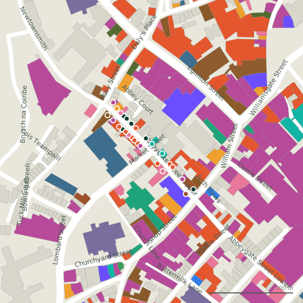
The street is drawn in black; buildings are coloured by what is in them. Drag to turn the model, tap a pin for the place.
Plan of the street
A walk along Abbeygate Street Upper
Start at the William Street end and walk towards Mary Street: 4 cafés, 3 restaurants, 2 takeaways, 2 hairdressers, 2 clothes shops and 2 phone shops and more share the 157 m. 12 of the 27 places on the street have opening hours on record, and 8 of them open on Sundays. There is parking on the street: Market Street Car Park and Mercy College Car Park.
What is on Abbeygate Street Upper
4 cafés, 3 restaurants, 2 takeaways, 2 hairdressers and 2 clothes shops and more, each with its own page.
Restaurants · 9
- Dungeons & DonutsTakeaways · hours on record
- Java's+353 91 533 330Cafés
- Little Collins CBD Dispensary+353 83 070 1983Cafés · hours on record
- Munch Haven+353 91 448 531Takeaways · hours on record
- Salsa+353 83 127 4457Restaurants
- The Chili Shack+353 91 393 805Restaurants
- The Lighthouse Cafe+353 91 568 706Cafés · hours on record
- Tuco’s Taqueria+353 91 563 925Restaurants · hours on record
Pubs · 1
- Sally Long’s+353 91 565 756Pubs · hours on record
Shops · 4
- Lally Menswear+353 91 564 883Clothes shops · hours on record
- Phonez N Fix+353 89 978 6819Phone shops
- Public RomanceClothes shops
- WeFix+353 87 909 3772Phone shops · hours on record
Hairdressers and beauty · 3
- Elisabeth CBeauty
- Gravity Hair Lounge+353 91 563 303Hairdressers
- Icon BarbershopHairdressers
Supermarkets · 1
- Asiatic ManilaConvenience stores · hours on record
Gyms and sport · 2
- Electric+353 91 565 976Nightclubs
Castles and heritage · 1
- Lynch's CastleMonuments
Other places · 6
- AlterEvaTailor
- AWOL Piercing+353 91 441 942Piercing
- Great Escape Rooms+353 91 536 979Escape game
- Jaycee+353 91 564 090Copyshop
- PlumesTobacco
- RitualsCosmetics
Streets it joins
- Abbeygate Street Lowerpedestrianised street · 18 places
- Bowling Greenresidential street · 1 place
- Market Streetlink road · 10 places
- Mary Streetresidential street · 13 places
- Newtownsmithresidential street · 6 places
- Shop Streetpedestrianised street · 26 places
- William Streetpedestrianised street · 20 places
Questions people ask
Where is Abbeygate Street Upper?
How long is Abbeygate Street Upper?
What is on Abbeygate Street Upper?
Is there a bus stop on Abbeygate Street Upper?
Where can I park near Abbeygate Street Upper?
Browse by kind
- Cafés in Galway
- Restaurants in Galway
- Takeaways in Galway
- Hairdressers in Galway
- Clothes shops in Galway
- Phone shops in Galway
- Tailor in Galway
- Convenience stores in Galway
- Piercing in Galway
- Nightclubs in Galway
- Beauty in Galway
- Gyms in Galway
- Escape game in Galway
- Copyshop in Galway
- Monuments in Galway
- Tobacco in Galway
- Cosmetics in Galway
- Pubs in Galway
- All 840 streets
Geometry, names and places from OpenStreetMap, read on 2026-09-18. Length is the sum of the mapped segments carrying this name; distances are straight lines from the street's midpoint.