Abbeygate Street Lower
Abbeygate Street Lower is the L5074, a pedestrianised street in Galway, 244 m south-west of Eyre Square. It runs 163 m from Merchants Road to William Street, about 2 minutes on foot end to end. It has 18 named places on the map: 2 cafés, bookshop, takeaway and bakery and more.
- Type
- Pedestrianised street (L5074)
- Length
- 163 m of mapped road
- From Eyre Square
- 244 m south-west
- Joins
- Abbeygate Street Upper, Merchants Road, Middle Street, Saint Augustine Street, Shop Street, Whitehall, William Street
- Runs
- from Merchants Road to William Street
- Nearest bus stop
- Merchants Road, 174 m away
- Parking
- 1 car park on the street: Eyre Square Centre Car Park
- Density
- 18 named places over 163 m, 11 per 100 m
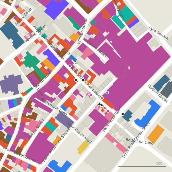
The street is drawn in black; buildings are coloured by what is in them. Drag to turn the model, tap a pin for the place.
Plan of the street
A walk along Abbeygate Street Lower
Start at the Merchants Road end and walk towards William Street: 2 cafés, a bookshop, a takeaway, a bakery, a jeweller and a convenience store and more share the 163 m. 7 of the 18 places on the street have opening hours on record, and 5 of them open on Sundays. There is parking on the street: Eyre Square Centre Car Park.
What is on Abbeygate Street Lower
2 cafés, 1 bookshops, 1 takeaways, 1 bakeries and 1 jewellers and more, each with its own page.
Restaurants · 4
- Aryan Pizzeria+353 91 707 868Takeaways
- Gourmet Tart Co.+353 91 539 710Cafés
- Pascal Coffee HouseCafés · hours on record
- Venice+353 91 530 751Restaurants
Shops · 5
- Aisling Family BookshopBookshops
- Blacoe Jewellers+353 91 561 003Jewellers
- Fresh CutsClothes shops
- Iré IslandGift shops
- Oxfam+353 91 561 491Charity shops · hours on record
Hairdressers and beauty · 2
- H&GHairdressers
- Junior Tattoo StudioTattoo studios · hours on record
Supermarkets · 1
- Candy CloudConvenience stores
Doctors · 1
- Whitehall Medical Centre+353 91 564 241Clinics · hours on record
Other places · 5
- BakeBoxBakeries
- Merchants GateBike hire
- MishnócLeather
- Romero GamesCompanies
- The Beauty MintCosmetics
Streets it joins
- Abbeygate Street Upperpedestrianised street · 27 places
- Merchants Roadregional road · 19 places
- Middle Streetminor road · 25 places
- Saint Augustine Streetminor road · 12 places
- Shop Streetpedestrianised street · 26 places
- Whitehallresidential street · 6 places
- William Streetpedestrianised street · 20 places
Questions people ask
Where is Abbeygate Street Lower?
How long is Abbeygate Street Lower?
What is on Abbeygate Street Lower?
Is there a bus stop on Abbeygate Street Lower?
Where can I park near Abbeygate Street Lower?
Browse by kind
- Cafés in Galway
- Bookshops in Galway
- Takeaways in Galway
- Bakeries in Galway
- Jewellers in Galway
- Convenience stores in Galway
- Clothes shops in Galway
- Hairdressers in Galway
- Gift shops in Galway
- Tattoo studios in Galway
- Bike hire in Galway
- Leather in Galway
- Charity shops in Galway
- Companies in Galway
- Cosmetics in Galway
- Restaurants in Galway
- Clinics in Galway
- All 840 streets
Geometry, names and places from OpenStreetMap, read on 2026-09-18. Length is the sum of the mapped segments carrying this name; distances are straight lines from the street's midpoint.