Rahoon Road
Rahoon Road is the L1015, a link road in Galway, 2.7 km west of Eyre Square. It runs 3.5 km from Maunsell's Road to Ballymoneen Road, about 44 minutes on foot end to end. It has 2 named places on the map: funeral director and hardware.
- Type
- Link road (L1015)
- Length
- 3.5 km of mapped road
- From Eyre Square
- 2.7 km west
- Joins
- An Bhuaile Bheag, Asca Beag, Ballymoneen Road, Bishop O'Donnell Road, Bóthar Dhiarmada, Bóthar Stiofáin, Circular Road, Clybaun Road Upper, Cruachan Park, Gleann Dara, Gort Gréine, Highfield Park, Maunsell's Road, Miller's Lane, Mincloon, Mount Pleasant Drive, New Avenue, Old Seamus Quirke Road, Rockfield Park, Ros Geal, Rosán Glas, Seamus Quirke Road, Shantalla Place, Shantalla Road, Slí na Craoibhe
- Runs
- from Maunsell's Road to Ballymoneen Road
- Bus stops
- Maunsells Road; Unnamed stop; Gleann Dara; Rahoon Road - Bus Depot; Rahoon Road - Rosán Glas; Rahoon Road Estate; Seamus Quirke Road; Rahoon Road - Rockfield Park; Unnamed stop; Unnamed stop; Unnamed stop
- Nearest parking
- Car Park 3, 1.4 km away
- Density
- 2 named places over 3.5 km, 0.1 per 100 m
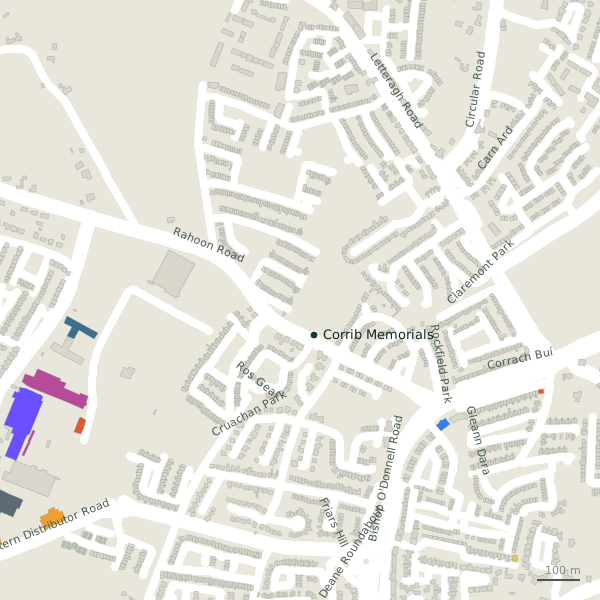
The street is drawn in black; buildings are coloured by what is in them. Drag to turn the model, tap a pin for the place.
Plan of the street
A walk along Rahoon Road
Start at the Maunsell's Road end and walk towards Ballymoneen Road: a funeral director and a hardware share the 3.5 km. Buses stop on the street itself at 11 stops.
What is on Rahoon Road
1 funeral directors and 1 hardware, each with its own page.
Shops · 1
- T O'Higgins & Co HardwareHardware
Other places · 1
- Corrib Memorials+353 86 258 9477Funeral directors
Streets it joins
- An Bhuaile Bheaglink road
- Asca Beagresidential street
- Ballymoneen Roadlink road · 1 place
- Bishop O'Donnell Roadregional road · 1 place
- Bóthar Dhiarmadaminor road
- Bóthar Stiofáinlink road
- Circular Roadlink road · 2 places
- Clybaun Road Upperlink road · 2 places
- Cruachan Parkresidential street
- Gleann Dararesidential street · 1 place
- Gort Gréineresidential street
- Highfield Parkresidential street
- Maunsell's Roadresidential street
- Miller's Lanecycle path · 1 place
- Mincloonresidential street
- Mount Pleasant Driveresidential street
- New Avenueresidential street
- Old Seamus Quirke Roadlink road · 10 places
- Rockfield Parkresidential street
- Ros Gealresidential street
- Rosán Glasresidential street · 2 places
- Seamus Quirke Roadlink road · 25 places
- Shantalla Placeresidential street
- Shantalla Roadlink road · 2 places
- Slí na Craoibheresidential street
Questions people ask
Where is Rahoon Road?
How long is Rahoon Road?
What is on Rahoon Road?
Is there a bus stop on Rahoon Road?
Where can I park near Rahoon Road?
Geometry, names and places from OpenStreetMap, read on 2026-09-18. Length is the sum of the mapped segments carrying this name; distances are straight lines from the street's midpoint.