link road · L5131 · $Galway, County Galway
Ballymoneen Road
Ballymoneen Road is the L5131, a link road in Galway, 4.6 km west of Eyre Square. It runs 2.4 km from Barna Road to Rahoon Road, about 30 minutes on foot end to end. It has 1 named place on the map: churche.
- Type
- Link road (L5131)
- Length
- 2.4 km of mapped road
- From Eyre Square
- 4.6 km west
- Joins
- An Bhuaile Bheag, Ard Cré, Ashleigh Grove, Barna Road, Blake Roundabout, Bóthar Bhaile na mBúrcach, Doire Beag, Drisín, Fána Buí, Gleann na Móna, Leas Na Mara, Leitir Búrca, Maigh Búrca, Monalee Heights, Monalee Manor, Portacarron, Radharc Na Farraige, Rahoon Road, Seacrest, Shangort Road, Slí Búrca, Slí Gheal, The Links, Tudor Close, Westbrook
- Runs
- from Barna Road to Rahoon Road
- Bus stops
- Ashleigh Grove; Westbrook; Tudor Close; Portacarron; Monalee Manor; Ballymoneen Road - Church; Unnamed stop
- Nearest parking
- National Aquarium Car Park on Seapoint Promenade, 3.1 km away
- Density
- 1 named place over 2.4 km, 0 per 100 m
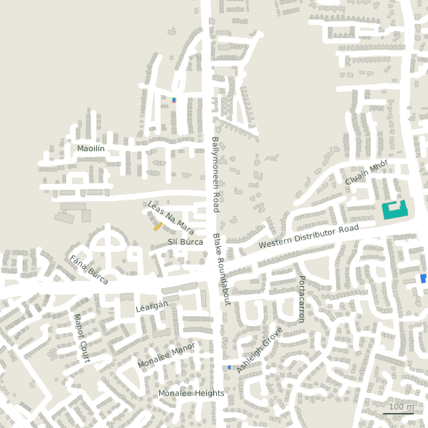
The street is drawn in black; buildings are coloured by what is in them. Drag to turn the model, tap a pin for the place.
Plan of the street
A walk along Ballymoneen Road
Start at the Barna Road end and walk towards Rahoon Road: a church share the 2.4 km. Buses stop on the street itself at 7 stops.
What is on Ballymoneen Road
1 churche, each with its own page.
Churches · 1
- Saint John the Apostle+353 91 590 059Churches
Streets it joins
- An Bhuaile Bheaglink road
- Ard Créresidential street
- Ashleigh Groveresidential street · 1 place
- Barna Roadresidential street · 5 places
- Blake Roundaboutlink road
- Bóthar Bhaile na mBúrcachminor road
- Doire Beagresidential street
- Drisínresidential street
- Fána Buíresidential street
- Gleann na Mónaresidential street
- Leas Na Mararesidential street · 1 place
- Leitir Búrcaresidential street
- Maigh Búrcaresidential street
- Monalee Heightsresidential street
- Monalee Manorresidential street
- Portacarronresidential street
- Radharc Na Farraigeresidential street
- Rahoon Roadlink road · 2 places
- Seacrestresidential street · 5 places
- Shangort Roadlink road · 9 places
- Slí Búrcaresidential street
- Slí Ghealresidential street · 3 places
- The Linksresidential street
- Tudor Closeresidential street
- Westbrookresidential street
Questions people ask
Where is Ballymoneen Road?
In Galway, County Galway, 4.6 km west of Eyre Square, joining An Bhuaile Bheag, Ard Cré and Ashleigh Grove.
How long is Ballymoneen Road?
2.4 km, measured along the mapped centre line; about 30 minutes on foot end to end.
What is on Ballymoneen Road?
1 named place: Saint John the Apostle.
Is there a bus stop on Ballymoneen Road?
Yes: Ashleigh Grove, Westbrook, Tudor Close, Portacarron, Monalee Manor, Ballymoneen Road - Church and Unnamed stop.
Where can I park near Ballymoneen Road?
The nearest car park is National Aquarium Car Park on Seapoint Promenade, 3.1 km away.
Browse by kind
Geometry, names and places from OpenStreetMap, read on 2026-09-18. Length is the sum of the mapped segments carrying this name; distances are straight lines from the street's midpoint.