Pubs · The Square · Mountbellew
The Hawthorne
The Hawthorne is a pub on The Square in Mountbellew, County Galway, 136 m north-east of the Square. All Sports, Kelly’s and Henry’s are within 33 m.
- Kind
- Pubs
- Street
- The Square
- From the Square
- 136 m north-east
- Parking
- Mountbellew Square, 28 m away
- Bus stop
- Mountbellew, 36 m away
The map does not yet record a phone number, a website or opening hours for The Hawthorne. Anyone can add them on OpenStreetMap; this page picks the change up at the next refresh.
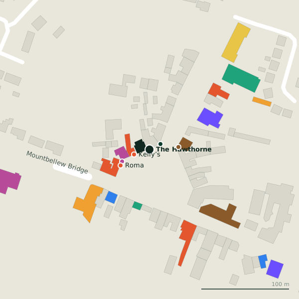
The building in black is this one; drag to turn the model.Open the whole town
Plan of the surrounding 300 m
Getting to The Hawthorne
- By car
- Park at Mountbellew Square, 28 m away, free, 27 spaces. Mountbellew is 42 km from Galway city.
- By bus
- The nearest stop is Mountbellew, 36 m away.
- Directions from where you are
- Open the model above, tap the pin and choose “Directions here”; the route is drawn from your own position.
While you are there
8 places to eat and drink within 300 m: Kelly’s (19 m), Henry’s (33 m), Roma (37 m) and The Bridge Bar (45 m) and more.
5 shops within 300 m, including Briggs, Costcutter and SuperValu.
The Square itself has 7 named places on the map.
Within a short walk
- All Sports14 mBookmaker
- Kelly’s18 mCafés
- Henry’s33 mPubs
- Briggs34 mClothes shops
- Roma37 mTakeaways
- The Bridge Bar45 mPubs
- Geraghty's Family Butcher46 mButchers
- Mountbellew Garda Station61 mGarda station
Also on The Square
- Henry’sPubs
- Kelly’sCafés
- Old ForgeMuseums
- The Bridge BarPubs
- The Malt HousePubs
- The Square KitchenRestaurants
Other pubs in Mountbellew
- Henry’s33 mThe Square
- The Bridge Bar45 mThe Square
- The Malt House111 mThe Square
Questions people ask
Where is The Hawthorne?
On The Square in Mountbellew, 136 m north-east of the Square; the nearest car park is 28 m away.
Are there other pubs nearby?
3 other pubs in $Mountbellew; the closest is Henry’s, 33 m away.
Source record: OpenStreetMap node/5098794447, read on 2026-09-18. The street is the mapped address where there is one, otherwise the nearest named road. Distances are straight lines.