Pharmacies · Roscam House · Galway
Nevins Pharmacy
Nevins Pharmacy is a pharmacy on Roscam House in Galway, County Galway, 5.0 km east of Eyre Square. Roscam Family Dental Practice, Stylistic Hair & Beauty and Roscam Medical Practice are within 16 m.
- Kind
- Pharmacies
- Street
- Roscam House
- From Eyre Square
- 5.0 km east
- Wheelchair
- Accessible
- Bus stop
- Stop (Bus Éireann), 172 m away
The map does not yet record a phone number, a website or opening hours for Nevins Pharmacy. Anyone can add them on OpenStreetMap; this page picks the change up at the next refresh.
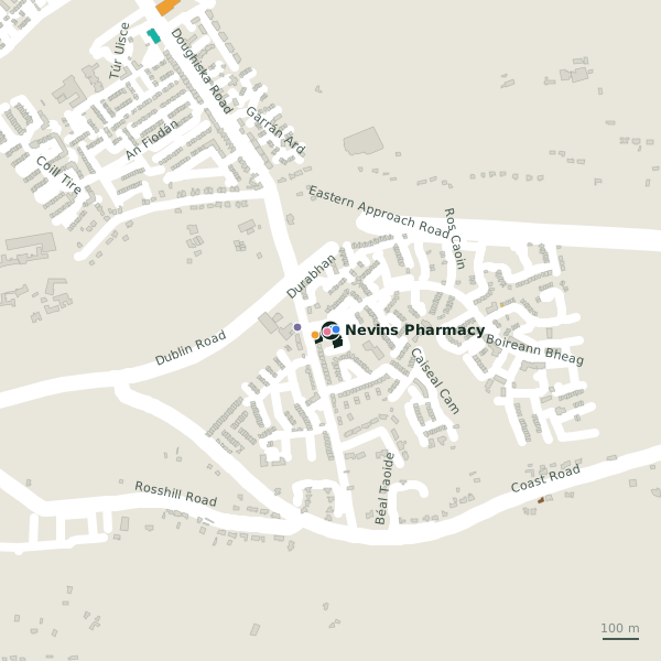
The building in black is this one; drag to turn the model.Open the whole town
Plan of the surrounding 300 m
Getting to Nevins Pharmacy
- By bus
- The nearest stop is an unnamed stop, served by Bus Éireann, 172 m away, with a shelter.
- Directions from where you are
- Open the model above, tap the pin and choose “Directions here”; the route is drawn from your own position.
While you are there
1 shop within 300 m, including Spar.
Roscam House itself has 5 named places on the map.
Within a short walk
- Roscam Family Dental Practice7 mDentists
- Stylistic Hair & Beauty11 mHairdressers
- Roscam Medical Practice16 mDoctors
- Spar44 mConvenience stores
- Good Shepherd Parish91 mChurches
- Cheshire House99 mSocial services
Also on Roscam House
- Roscam Family Dental PracticeDentists
- Roscam Medical PracticeDoctors
- SparConvenience stores
- Stylistic Hair & BeautyHairdressers
Other pharmacies in Galway
- Merlin Pharmacy1.2 kmDoughiska Road
- 1.8 km
- Ballybane Pharmacy2.7 kmBallybane Road
- Mervue Pharmacy3.1 kmPlunket Avenue
- Duggan's Pharmacy3.2 kmRenmore Road
- Renmore Pharmacy3.3 kmRenmore Road
- Boots3.9 kmWellpark Retail Centre
- Haven Pharmacy4.2 kmTuam Road
Questions people ask
Where is Nevins Pharmacy?
On Roscam House in Galway, 5.0 km east of Eyre Square.
Are there other pharmacies nearby?
36 other pharmacies in $Galway; the closest is Merlin Pharmacy, 1.2 km away.
Source record: OpenStreetMap node/1986317548, read on 2026-09-18. The street is the mapped address where there is one, otherwise the nearest named road. Distances are straight lines.