Peig’s Bar
Peig’s Bar is a pub on Bohermore in Galway, County Galway, 358 m north-east of Eyre Square. Sophies, Crowe’s Sports Bar and Power Gym Galway are within 21 m.
The map does not yet record a phone number, a website or opening hours for Peig’s Bar. Anyone can add them on OpenStreetMap; this page picks the change up at the next refresh.
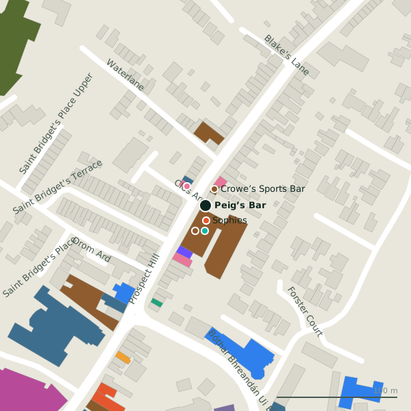
Plan of the surrounding 300 m
Getting to Peig’s Bar
- By car
- Park at Corrib Centre Car Park, 306 m away, paid.
- By bus
- The nearest stop is Prospect Hill, served by Bus Éireann, 21 m away.
- Directions from where you are
- Open the model above, tap the pin and choose “Directions here”; the route is drawn from your own position.
While you are there
25 places to eat and drink within 300 m: Sophies (13 m), Crowe’s Sports Bar (15 m), Elephant and Castle (32 m) and Harry’s (54 m) and more.
13 shops within 300 m, including Armazém Brazil, TK Maxx and Corrib Shopping Centre.
Bohermore itself has 9 named places on the map.
Within a short walk
- Sophies13 mRestaurants
- 15 m
- Power Gym Galway21 mGyms
- Art Tattoo22 mTattoo studios
- The Dean22 mHotels
- City Property Services23 mEstate agents
- Fade Factory23 mHairdressers
- Elephant and Castle32 mRestaurants
Also on Bohermore
- Art TattooTattoo studios
- Bohermore Cemetery ChapelChurches
- Cemetery ChapelChurches
- Circle KCar wash
- City Property ServicesEstate agents
- Fade FactoryHairdressers
- Harry’sPubs
Other pubs in Galway
- Crowe’s Sports Bar15 mBohermore
- Harry’s54 mBohermore
- The Ol’ 55190 mProspect Hill
- Screene's on the Square247 mProspect Hill
- Murty Rabbit’s279 mForster Street
- Kennedy’s283 mEyre Square
- Jack J. Foley’s291 mEyre Square
- Fibber Magee’s297 mEyre Square
Questions people ask
Where is Peig’s Bar?
Are there other pubs nearby?
Source record: OpenStreetMap node/10751780928, read on 2026-09-18. The street is the mapped address where there is one, otherwise the nearest named road. Distances are straight lines.