ReproMed Galway
ReproMed Galway is a clinic on Western Distributor Road in Galway, County Galway, 3.2 km west of Eyre Square. RSA Insurance, Gaelscoil Mhic Amhlaidh and Carraig Donn are within 156 m.
- Kind
- Clinics
- Street
- Western Distributor Road
- From Eyre Square
- 3.2 km west
- Website
- repromed.ie
- Wheelchair
- Accessible
- Bus stop
- Aviva (CityDirect), 101 m away
The map does not yet record a phone number or opening hours for ReproMed Galway. Anyone can add them on OpenStreetMap; this page picks the change up at the next refresh.
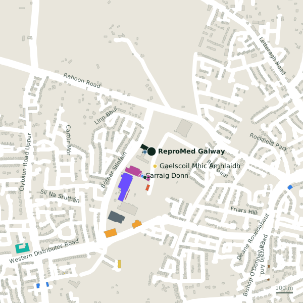
Plan of the surrounding 300 m
Getting to ReproMed Galway
- By bus
- The nearest stop is Aviva, served by CityDirect, 101 m away.
- Directions from where you are
- Open the model above, tap the pin and choose “Directions here”; the route is drawn from your own position.
While you are there
4 places to eat and drink within 300 m: Synge & Byrne (182 m), KFC (206 m), Costa (225 m) and PizzaList (244 m).
5 shops within 300 m, including Carraig Donn, Regatta Great Outdoors and Petstop.
Western Distributor Road itself has 29 named places on the map.
Within a short walk
- RSA Insurance40 mInsurance
- Gaelscoil Mhic Amhlaidh90 mSchools
- Carraig Donn156 mClothes shops
- Specsavers157 mOpticians
- Evergreen158 mHealth food
- Regatta Great Outdoors158 mOutdoor shops
- Boots161 mPharmacies
- Petstop161 mPet shops
Also on Western Distributor Road
- AldiSupermarkets
- B&QHardware
- B&Q Garden CentreGarden centres
- BootsPharmacies
- Carraig DonnClothes shops
- Dunnes StoresSupermarkets
- EcoFuel Ware+Store® GalwayPetrol stations
Everything on Western Distributor Road (29 places)
Other clinics in Galway
- OxyGeneration3.0 kmMerchants Road
- Whitehall Medical Centre3.1 kmAbbeygate Street Lower
- Headford Road Medical Clinic3.6 kmHeadford Road
- Med Aesthetics3.8 kmSean Mulvoy Road
- Carepoint Medical Centre3.9 kmSean Mulvoy Road
- HSE Medical Centre5.4 kmSaint James Crescent
- Lá Nua Psychiatric Day Hospital6.4 kmBallybane Village
- 7.4 km
Questions people ask
Where is ReproMed Galway?
Are there other clinics nearby?
Source record: OpenStreetMap node/1868456501, read on 2026-09-18. The street is the mapped address where there is one, otherwise the nearest named road. Distances are straight lines.