Samaritans
Samaritans is a social service on Nun's Island in Galway, County Galway, 579 m west of Eyre Square. Kilduff's, Saint Joseph's Patrician College and Nun's Island Theatre are within 67 m.
- Kind
- Social services
- Street
- 14 Nun's Island
- From Eyre Square
- 579 m west
- Run by
- Samaritans
- Parking
- Cathedral on Gaol Road, 150 m away
- Bus stop
- Stop, 151 m away
The map does not yet record a phone number, a website or opening hours for Samaritans. Anyone can add them on OpenStreetMap; this page picks the change up at the next refresh.
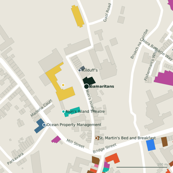
Plan of the surrounding 300 m
Getting to Samaritans
- By car
- Park at Cathedral on Gaol Road, 150 m away, paid, 162 spaces.
- By bus
- The nearest stop is an unnamed stop, 151 m away.
- Directions from where you are
- Open the model above, tap the pin and choose “Directions here”; the route is drawn from your own position.
While you are there
81 places to eat and drink within 300 m: Galway Arms Inn (146 m), IL Vicolo (149 m), BóTOWN (168 m) and M.P. Walsh (174 m) and more.
47 shops within 300 m, including Don't Call Me Dear Boutique, Corless Formalwear and Bridge Stores.
Nun's Island itself has 6 named places on the map, and 2 car parks along it.
Within a short walk
- Kilduff's35 mGarages
- 46 m
- Nun's Island Theatre67 mTheatre
- St. Martin's Bed and Breakfast103 mGuest houses
- Ocean Property Management112 mEstate agents
- Don't Call Me Dear Boutique117 mClothes shops
- Gaol Road121 mBike hire
- Galway Library Services140 mLibrary
Also on Nun's Island
- Kilduff'sGarages
- Nun's Island TheatreTheatre
- Poor Clares ConventMonastery
- St. Martin's Bed and BreakfastGuest houses
Other social services in Galway
- Order of Malta303 mSaint Helens Street
- Saint Mary's Residential Centre586 mShantalla Road
- Fairgreen Homeless Men's Hostel818 mFairgreen Road
- Galway Rape Crisis Centre910 mForster Court
- Osterley Lodge1.4 kmLower Salthill Road
- St. Francis Primary & Daycare1.5 kmUpper Newcastle Road
- Glenoaks Hotel1.8 kmBishop O'Donnell Road
- Galway Centre for Independant Living1.9 kmTown Park Centre
Questions people ask
Where is Samaritans?
Are there other social services nearby?
Source record: OpenStreetMap node/1865469177, read on 2026-09-18. The street is the mapped address where there is one, otherwise the nearest named road. Distances are straight lines.