Lower Salthill Road
Lower Salthill Road is the R864, a regional road in Galway, 1.6 km south-west of Eyre Square. It runs 959 m from Upper Salthill Road to The Crescent, about 12 minutes on foot end to end. It has 20 named places on the map: 2 hotels, dentist, atelier and college and more.
- Type
- Regional road (R864)
- Length
- 959 m of mapped road
- From Eyre Square
- 1.6 km south-west
- Joins
- Churchfields, Cúl Trá, Devon Park, Father Griffin Road, Grattan Road, Lenaboy Park, Lios Ealtán, Rosmeen Court, Saint Mary's Avenue, Saint Mary's Road, Taylor's Hill Road, The Crescent, Upper Salthill Road, Whitestrand Avenue
- Runs
- from Upper Salthill Road to The Crescent
- Bus stops
- Salthill Road Lower; Devon Park; St Mary's Avenue; Salthill Road Lower; Lios Ealtan; Lios Ealtan; Devon Park
- Nearest parking
- Claude Toft Car Park on Seapoint Promenade, 753 m away
- Density
- 20 named places over 959 m, 2.1 per 100 m
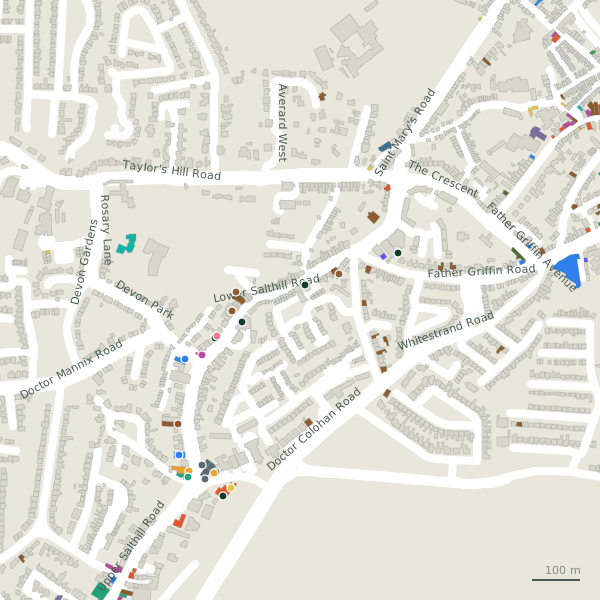
The street is drawn in black; buildings are coloured by what is in them. Drag to turn the model, tap a pin for the place.
Plan of the street
A walk along Lower Salthill Road
Start at the Upper Salthill Road end and walk towards The Crescent: 2 hotels, a dentist, an atelier, a college, a language school and a speech therapist and more share the 959 m. 6 of the 20 places on the street have opening hours on record, and 4 of them open on Sundays. Buses stop on the street itself at 7 stops.
What is on Lower Salthill Road
2 hotels, 1 dentists, 1 atelier, 1 colleges and 1 language school and more, each with its own page.
Pubs · 1
- P.J. Flaherty+35391373734Pubs
Shops · 1
- Knocknacarra Florist+353 91 58 66 66Florists · hours on record
Hairdressers and beauty · 1
- Shannon's Beauty Suites+353 85 262 5418Beauty
Pharmacies · 1
- Stauntons AllcarePharmacies
Doctors · 2
- Devon Park Dental+353 91 520 222Dentists · hours on record
- Osterley Lodge+353 91 521 301Social services · hours on record
Schools · 1
- Galway Business School+353 91 529 000Colleges
Hotels · 3
- The Rio GuesthouseGuest houses · hours on record
- Ward's HotelHotels
Other places · 5
- Engage Art StudiosAtelier
- Galway Cultural Institute+353 91 863 100Language school
- Galway Speech Therapy+353 87 737 8531Speech therapist
- Kelly Office SuppliesStationery
- Stewart Construction+353 91 524 455Companies
Streets it joins
- Churchfieldsresidential street
- Cúl Tráresidential street
- Devon Parkresidential street
- Father Griffin Roadregional road · 18 places
- Grattan Roadminor road · 3 places
- Lenaboy Parkresidential street
- Lios Ealtánresidential street
- Rosmeen Courtresidential street
- Saint Mary's Avenueresidential street
- Saint Mary's Roadregional road · 2 places
- Taylor's Hill Roadregional road · 2 places
- The Crescentregional road
- Upper Salthill Roadregional road · 70 places
- Whitestrand Avenueresidential street · 4 places
Questions people ask
Where is Lower Salthill Road?
How long is Lower Salthill Road?
What is on Lower Salthill Road?
Is there a bus stop on Lower Salthill Road?
Where can I park near Lower Salthill Road?
Browse by kind
- Hotels in Galway
- Dentists in Galway
- Atelier in Galway
- Colleges in Galway
- Language school in Galway
- Speech therapist in Galway
- Garages in Galway
- Stationery in Galway
- Florists in Galway
- Supermarkets in Galway
- Social services in Galway
- Pubs in Galway
- Beauty in Galway
- Pharmacies in Galway
- Companies in Galway
- Car dealers in Galway
- Petrol stations in Galway
- Guest houses in Galway
- Convenience stores in Galway
- All 840 streets
Geometry, names and places from OpenStreetMap, read on 2026-09-18. Length is the sum of the mapped segments carrying this name; distances are straight lines from the street's midpoint.