regional road · R337 · $Galway, County Galway
Taylor's Hill Road
Taylor's Hill Road is the R337, a regional road in Galway, 2.0 km west of Eyre Square. It runs 1.6 km from Bishop O'Donnell Road to Saint Mary's Road, about 20 minutes on foot end to end. It has 2 named places on the map: hotel and gym.
- Type
- Regional road (R337)
- Length
- 1.6 km of mapped road
- From Eyre Square
- 2.0 km west
- Joins
- Ardmore, Averard West, Bishop O'Donnell Road, Kingston Road, Lower Salthill Road, Maunsell's Road, Mount Eaton, Rosary Lane, Rosedale, Saint Claires, Saint Mary's Avenue, Saint Mary's Park, Saint Mary's Road, Seapark, Sherwood Avenue, Suncroft Court, The Crescent, The Nurseries, Threadneedle Road
- Runs
- from Bishop O'Donnell Road to Saint Mary's Road
- Bus stops
- Sycamore Drive; Taylors Hill (Dominican Convent); St Anne's; St Anne's; Ardmore; Taylor's Hill Road; Ardmore; Lios Ealtan
- Nearest parking
- Claude Toft Car Park on Seapoint Promenade, 975 m away
- Density
- 2 named places over 1.6 km, 0.1 per 100 m
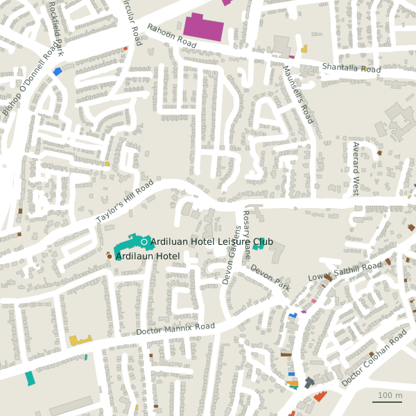
The street is drawn in black; buildings are coloured by what is in them. Drag to turn the model, tap a pin for the place.
Plan of the street
A walk along Taylor's Hill Road
Start at the Bishop O'Donnell Road end and walk towards Saint Mary's Road: a hotel and a gym share the 1.6 km. Buses stop on the street itself at 8 stops.
What is on Taylor's Hill Road
1 hotels and 1 gyms, each with its own page.
Gyms and sport · 1
Hotels · 1
- Ardilaun Hotel+353 91 521 433Hotels
Streets it joins
- Ardmoreresidential street
- Averard Westresidential street
- Bishop O'Donnell Roadregional road · 1 place
- Kingston Roadregional road · 10 places
- Lower Salthill Roadregional road · 20 places
- Maunsell's Roadresidential street
- Mount Eatonresidential street · 1 place
- Rosary Lanelink road · 1 place
- Rosedaleresidential street
- Saint Clairesresidential street
- Saint Mary's Avenueresidential street
- Saint Mary's Parkresidential street
- Saint Mary's Roadregional road · 2 places
- Seaparkresidential street
- Sherwood Avenueresidential street · 1 place
- Suncroft Courtresidential street
- The Crescentregional road
- The Nurseriesresidential street
- Threadneedle Roadregional road · 6 places
Questions people ask
Where is Taylor's Hill Road?
In Galway, County Galway, 2.0 km west of Eyre Square, joining Ardmore, Averard West and Bishop O'Donnell Road.
How long is Taylor's Hill Road?
1.6 km, measured along the mapped centre line; about 20 minutes on foot end to end.
What is on Taylor's Hill Road?
2 named places: Ardilaun Hotel and Ardiluan Hotel Leisure Club.
Is there a bus stop on Taylor's Hill Road?
Yes: Sycamore Drive, Taylors Hill (Dominican Convent), St Anne's, St Anne's, Ardmore, Taylor's Hill Road, Ardmore and Lios Ealtan.
Where can I park near Taylor's Hill Road?
The nearest car park is Claude Toft Car Park on Seapoint Promenade, 975 m away.
Browse by kind
Geometry, names and places from OpenStreetMap, read on 2026-09-18. Length is the sum of the mapped segments carrying this name; distances are straight lines from the street's midpoint.