Kingston Road
Kingston Road is the R337, a regional road in Galway, 3.5 km west of Eyre Square. It runs 1.7 km from Upper Salthill Road to Bishop O'Donnell Road, about 21 minutes on foot end to end. It has 10 named places on the map: 2 gyms, 2 social services, restaurant and churche and more.
- Type
- Regional road (R337)
- Length
- 1.7 km of mapped road
- From Eyre Square
- 3.5 km west
- Joins
- Barna Road, Bishop O'Donnell Road, Clybaun Road Lower, Dun a Ri, Garryowen Lane, Kingston Gardens, Knocknacarra Road, Manor Drive, Shangort Road, Slí Na Mara, Taylor's Hill Road, Threadneedle Road, Upper Salthill Road
- Runs
- from Upper Salthill Road to Bishop O'Donnell Road
- Bus stops
- Kingston Gardens; Kingston Road; Kingston Gardens; Manor Drive; Manor Drive
- Nearest parking
- National Aquarium Car Park on Seapoint Promenade, 1.8 km away
- Density
- 10 named places over 1.7 km, 0.6 per 100 m
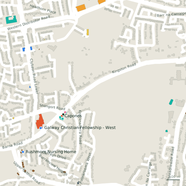
The street is drawn in black; buildings are coloured by what is in them. Drag to turn the model, tap a pin for the place.
Plan of the street
A walk along Kingston Road
Start at the Upper Salthill Road end and walk towards Bishop O'Donnell Road: 2 gyms, 2 social services, a restaurant, a church, a doctor and a convenience store and more share the 1.7 km. 5 of the 10 places on the street have opening hours on record, and 3 of them open on Sundays. Buses stop on the street itself at 5 stops.
What is on Kingston Road
2 gyms, 2 social services, 1 restaurants, 1 churches and 1 doctors and more, each with its own page.
Restaurants · 1
- Capones+353 91 520 060Restaurants · hours on record
Hairdressers and beauty · 1
- Platinum Tanning Studio+353 91 520 002Beauty · hours on record
Supermarkets · 1
- Orlik - Polski Sklep+353 87 982 2081Convenience stores · hours on record
Doctors · 3
- Kingston Medical Center+353 91 588 816Doctors · hours on record
- Knocknacarra District Community Scheme+353 91 863 675Social services
- Rushmore Nursing HomeSocial services
Gyms and sport · 2
- Educogym+353 91 523 904Gyms · hours on record
Churches · 1
Other places · 1
- Tribe Hospitality GroupCompanies
Streets it joins
- Barna Roadresidential street · 5 places
- Bishop O'Donnell Roadregional road · 1 place
- Clybaun Road Lowerlink road · 6 places
- Dun a Riresidential street
- Garryowen Laneresidential street
- Kingston Gardensresidential street
- Knocknacarra Roadresidential street
- Manor Driveresidential street
- Shangort Roadlink road · 9 places
- Slí Na Mararesidential street
- Taylor's Hill Roadregional road · 2 places
- Threadneedle Roadregional road · 6 places
- Upper Salthill Roadregional road · 70 places
Questions people ask
Where is Kingston Road?
How long is Kingston Road?
What is on Kingston Road?
Is there a bus stop on Kingston Road?
Where can I park near Kingston Road?
Geometry, names and places from OpenStreetMap, read on 2026-09-18. Length is the sum of the mapped segments carrying this name; distances are straight lines from the street's midpoint.