Keane’s
Keane’s is a pub on Main Street in Oranmore, County Galway, 127 m south-west of the centre. ORANCABS, Keanes Music Venue and Phoenix Barbers are within 25 m.
- Kind
- Pubs
- Street
- Main Street
- From the centre
- 127 m south-west
- Bus stop
- Stop, 134 m away
The map does not yet record a phone number, a website or opening hours for Keane’s. Anyone can add them on OpenStreetMap; this page picks the change up at the next refresh.
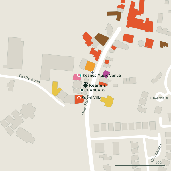
Plan of the surrounding 300 m
Getting to Keane’s
- By bus
- The nearest stop is an unnamed stop, 134 m away.
- Directions from where you are
- Open the model above, tap the pin and choose “Directions here”; the route is drawn from your own position.
While you are there
20 places to eat and drink within 300 m: Royal Villa (28 m), Santoor (40 m), Brazco (57 m) and Supermac's (62 m) and more.
6 shops within 300 m, including Centra, Vincent's and Aldi.
Main Street itself has 26 named places on the map.
Within a short walk
- ORANCABS12 mTaxi ranks
- Keanes Music Venue23 mNightclubs
- Phoenix Barbers25 mHairdressers
- Royal Villa28 mRestaurants
- Texaco30 mPetrol stations
- Santoor40 mRestaurants
- Centra49 mConvenience stores
- Vincent's49 mCharity shops
Also on Main Street
- Apache PizzaTakeaways
- Bank of IrelandBanks
- Bar One RacingBookmaker
- BrazcoCafés
- CentraConvenience stores
- Coach House HotelHotels
- Giovannis OranmoreTakeaways
Everything on Main Street (26 places)
Other pubs in Oranmore
- The Olde Brewery92 mMain Street
- Porterhouse110 mMain Street
- Mac Donagh145 mMain Street
- Glynn’s173 mDublin Road
- Q Bar1.1 kmCarrowmoneash Roundabout
Questions people ask
Where is Keane’s?
Are there other pubs nearby?
Source record: OpenStreetMap node/568037544, read on 2026-09-18. The street is the mapped address where there is one, otherwise the nearest named road. Distances are straight lines.