Pubs · Tuam Road · Galway
The Trappers Inn
The Trappers Inn is a pub on Tuam Road in Galway, County Galway, 2.3 km north-east of Eyre Square. Galway Primary Care, Complete Laboratory Solutions and Sasha Auto are within 83 m.
The map does not yet record a phone number, a website or opening hours for The Trappers Inn. Anyone can add them on OpenStreetMap; this page picks the change up at the next refresh.
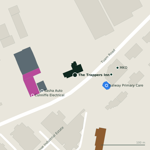
The building in black is this one; drag to turn the model.Open the whole town
Plan of the surrounding 300 m
Getting to The Trappers Inn
- By bus
- The nearest stop is an unnamed stop, served by Bus Éireann, 42 m away, with a shelter.
- Directions from where you are
- Open the model above, tap the pin and choose “Directions here”; the route is drawn from your own position.
While you are there
3 shops within 300 m, including Cunniffe Electrical, Cases Wine Warehouse and Spar.
Tuam Road itself has 101 named places on the map.
Within a short walk
- Galway Primary Care75 mDoctors
- Complete Laboratory Solutions82 mCompanies
- Sasha Auto83 mCar dealers
- MKO98 mCompanies
- Cunniffe Electrical106 mElectronics
- Musgrave MarketPlace113 mWholesale
- Cases Wine Warehouse115 mOff licences
- 120 m
Also on Tuam Road
- Ability WestCharity shops
- Ace PrintersPrinter ink
- African Pride StoreConvenience stores
- AIBCash machines
- All 4 BabyBaby goods
- ApplegreenPetrol stations
- Atlantic Print & DesignCopyshop
- Bank of IrelandCash machines
Everything on Tuam Road (101 places)
Other pubs in Galway
- The Huntsman Inn1.1 kmCollege Road
- Frankie's Bar & Bistro1.3 kmDublin Road
- The Clan Bar1.5 kmCollege Road
- The Merlin Bar2.0 kmDublin Road
- Harry’s2.0 kmBohermore
- Crowe’s Sports Bar2.0 kmBohermore
- Peig’s Bar2.0 kmBohermore
- The Ol’ 552.2 kmProspect Hill
Questions people ask
Where is The Trappers Inn?
On Tuam Road in Galway, 2.3 km north-east of Eyre Square.
Are there other pubs nearby?
74 other pubs in $Galway; the closest is The Huntsman Inn, 1.1 km away.
Source record: OpenStreetMap node/1734162474, read on 2026-09-18. The street is the mapped address where there is one, otherwise the nearest named road. Distances are straight lines.