College Road
College Road is the R339, a regional road in Galway, 1.0 km north-east of Eyre Square. It runs 1.1 km from Forster Street to Dublin Road, about 14 minutes on foot end to end. It has 12 named places on the map: 2 guest houses, 2 hotels, 2 pubs and petrol station and more.
- Type
- Regional road (R339)
- Length
- 1.1 km of mapped road
- From Eyre Square
- 1.0 km north-east
- Joins
- Dublin Road, Forster Street, Gleann Nóinín, Glenmore, Lough Atalia Road, Loyola Park, Moneenageisha Road, Seaview Court, The Green, Wellpark Road
- Runs
- from Forster Street to Dublin Road
- Bus stops
- Dublin Rd (Opp G Hotel); Loyola Park; College Road; Connacht Rugby; Loyola Park; Connacht Rugby; Yeats College
- Nearest parking
- Dyke Road Car Park on Dyke Road, 1.0 km away
- Density
- 12 named places over 1.1 km, 1.1 per 100 m
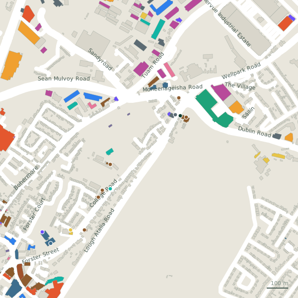
The street is drawn in black; buildings are coloured by what is in them. Drag to turn the model, tap a pin for the place.
Plan of the street
A walk along College Road
Start at the Forster Street end and walk towards Dublin Road: 2 guest houses, 2 hotels, 2 pubs, a petrol station, a stadium and a government office and more share the 1.1 km. 1 of the 12 places on the street has opening hours on record. Buses stop on the street itself at 7 stops.
What is on College Road
2 guest houses, 2 hotels, 2 pubs, 1 petrol stations and 1 stadium and more, each with its own page.
Pubs · 2
- The Clan BarPubs
- The Huntsman InnPubs
Schools · 1
- Yeats College+353 91 533 500Schools
Banks · 1
- Galway City HallCouncil offices
Offices and agents · 1
- Galway City Council+353 91 536 400Government offices · hours on record
Petrol · 1
- Circle KPetrol stations
Gyms and sport · 1
- Dexcom StadiumStadium
Hotels · 4
- Ardawn House+353 91 568833Guest houses
- Bay View HouseGuest houses
- The Urban Nest+353 91 563 315Hotels
Other places · 1
- Paddy PowerBookmaker
Streets it joins
- Dublin Roadregional road · 24 places
- Forster Streetregional road · 26 places
- Gleann Nóinínresidential street
- Glenmoreresidential street
- Lough Atalia Roadlink road · 7 places
- Loyola Parkresidential street
- Moneenageisha Roadregional road
- Seaview Courtresidential street
- The Greenresidential street
- Wellpark Roadresidential street · 1 place
Questions people ask
Where is College Road?
How long is College Road?
What is on College Road?
Is there a bus stop on College Road?
Where can I park near College Road?
Geometry, names and places from OpenStreetMap, read on 2026-09-18. Length is the sum of the mapped segments carrying this name; distances are straight lines from the street's midpoint.